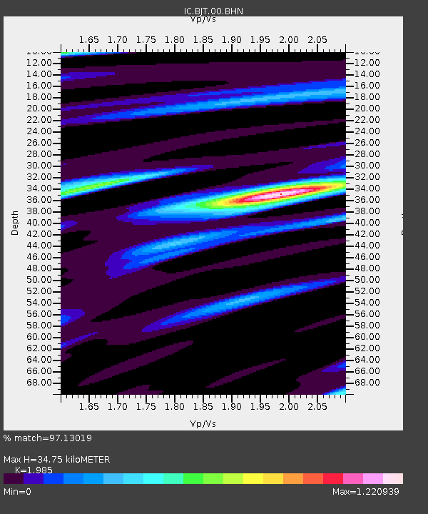
BJT Baijiatuan, Beijing, China - Earthquake Result Viewer
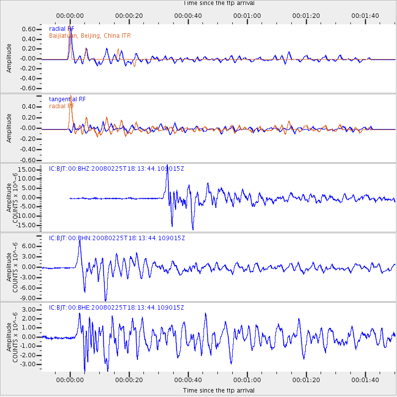
Earthquake location: Southern Sumatra, Indonesia
Earthquake latitude/longitude: -2.3/99.9
Earthquake time(UTC): 2008/02/25 (056) 18:06:03 GMT
Earthquake Depth: 25 km
Earthquake Magnitude: 6.0 MB, 6.4 MS, 6.4 MW, 6.3 MW
Earthquake Catalog/Contributor: WHDF/NEIC
Network: IC New China Digital Seismograph Network
Station: BJT Baijiatuan, Beijing, China
Lat/Lon: 40.02 N/116.17 E
Elevation: 197 m
Distance: 44.7 deg
Az: 17.816 deg
Baz: 203.458 deg
Ray Param: 0.07170963
Estimated Moho Depth: 34.75 km
Estimated Crust Vp/Vs: 1.99
Assumed Crust Vp: 6.464 km/s
Estimated Crust Vs: 3.256 km/s
Estimated Crust Poisson's Ratio: 0.33
Radial Match: 97.13019 %
Radial Bump: 400
Transverse Match: 91.48358 %
Transverse Bump: 400
SOD ConfigId: 2564
Insert Time: 2010-03-04 21:21:19.694 +0000
GWidth: 2.5
Max Bumps: 400
Tol: 0.001

Signal To Noise

ChannelStoNSTALTA
IC:BJT:00:BHN:20080225T18:13:44.109015Z39.267383.08666E-67.860621E-8
IC:BJT:00:BHE:20080225T18:13:44.109015Z10.9380141.1054561E-61.01065524E-7
IC:BJT:00:BHZ:20080225T18:13:44.109015Z44.5628056.827281E-61.5320582E-7
Arrivals
Ps5.6 SECOND
PpPs15 SECOND
PsPs/PpSs21 SECOND