You are here: Home > Network List > IC - New China Digital Seismograph Network Stations List
> Station BJT Baijiatuan, Beijing, China > Earthquake Result Viewer
BJT Baijiatuan, Beijing, China - Earthquake Result Viewer
| Earthquake location: |
Northern Sumatra, Indonesia |
| Earthquake latitude/longitude: |
1.0/97.4 |
| Earthquake time(UTC): |
2008/01/22 (022) 17:14:57 GMT |
| Earthquake Depth: |
20 km |
| Earthquake Magnitude: |
5.9 MB, 6.2 MW, 6.1 MW |
| Earthquake Catalog/Contributor: |
WHDF/NEIC |
|
| Network: |
IC New China Digital Seismograph Network |
| Station: |
BJT Baijiatuan, Beijing, China |
| Lat/Lon: |
40.02 N/116.17 E |
| Elevation: |
197 m |
|
| Distance: |
42.4 deg |
| Az: |
21.445 deg |
| Baz: |
208.425 deg |
| Ray Param: |
0.0731706 |
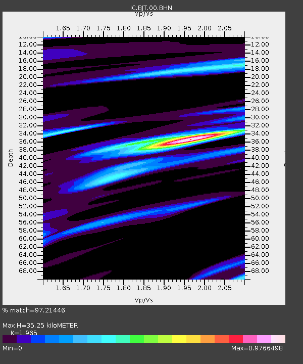
| Estimated Moho Depth: |
35.25 km |
| Estimated Crust Vp/Vs: |
1.97 |
| Assumed Crust Vp: |
6.464 km/s |
| Estimated Crust Vs: |
3.289 km/s |
| Estimated Crust Poisson's Ratio: |
0.33 |
|
| Radial Match: |
97.21446 % |
| Radial Bump: |
305 |
| Transverse Match: |
91.88772 % |
| Transverse Bump: |
400 |
| SOD ConfigId: |
2564 |
| Insert Time: |
2010-03-04 21:21:38.315 +0000 |
| GWidth: |
2.5 |
| Max Bumps: |
400 |
| Tol: |
0.001 |
|
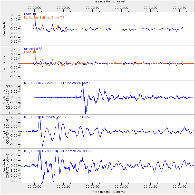
Signal To Noise
| Channel | StoN | STA | LTA |
| IC:BJT:00:BHN:20080122T17:22:20.261005Z | 39.262863 | 2.7158367E-6 | 6.9170625E-8 |
| IC:BJT:00:BHE:20080122T17:22:20.261005Z | 12.127837 | 1.2035474E-6 | 9.923841E-8 |
| IC:BJT:00:BHZ:20080122T17:22:20.261005Z | 49.049164 | 5.398533E-6 | 1.10063716E-7 |
| Arrivals |
| Ps | 5.6 SECOND |
| PpPs | 15 SECOND |
| PsPs/PpSs | 21 SECOND |


