You are here: Home > Network List > US - United States National Seismic Network Stations List
> Station HAWA Hanford, Washington, USA > Earthquake Result Viewer
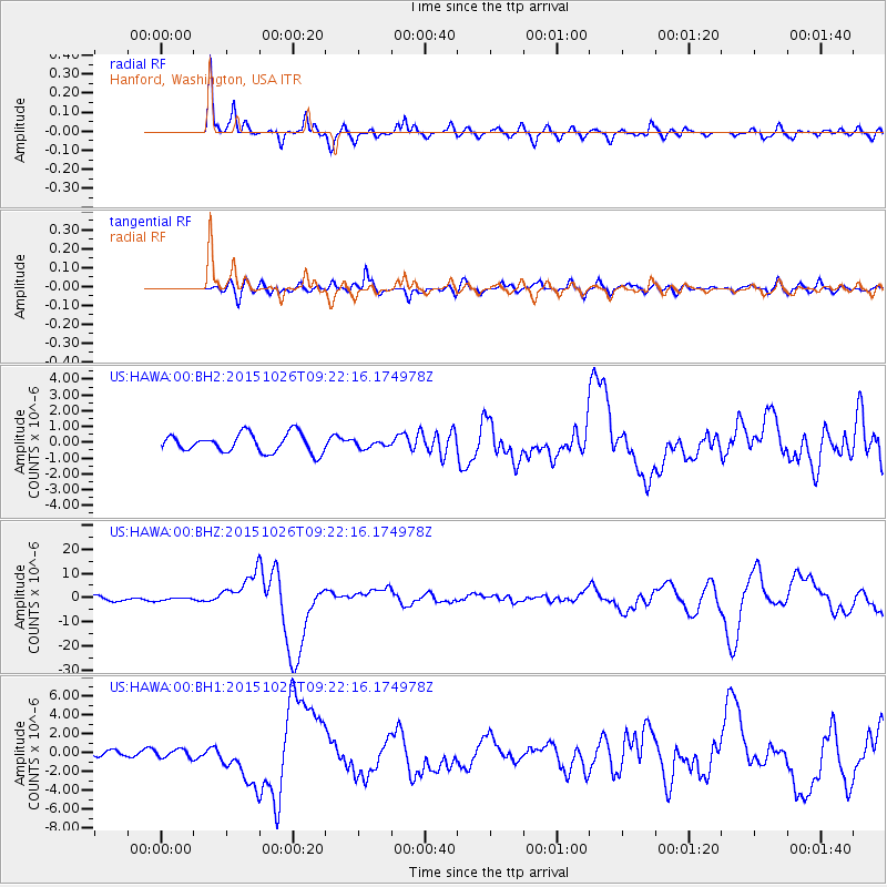
HAWA Hanford, Washington, USA - Earthquake Result Viewer
*The percent match for this event was below the threshold and hence no stack was calculated.
| Earthquake location: |
Hindu Kush Region, Afghanistan |
| Earthquake latitude/longitude: |
36.4/70.7 |
| Earthquake time(UTC): |
2015/10/26 (299) 09:09:32 GMT |
| Earthquake Depth: |
212 km |
| Earthquake Magnitude: |
7.5 MWW, 7.5 MWB |
| Earthquake Catalog/Contributor: |
NEIC PDE/NEIC COMCAT |
|
| Network: |
US United States National Seismic Network |
| Station: |
HAWA Hanford, Washington, USA |
| Lat/Lon: |
46.39 N/119.53 W |
| Elevation: |
364 m |
|
| Distance: |
97.0 deg |
| Az: |
7.128 deg |
| Baz: |
351.688 deg |
| Ray Param: |
$rayparam |
*The percent match for this event was below the threshold and hence was not used in the summary stack. |
|
| Radial Match: |
92.777054 % |
| Radial Bump: |
400 |
| Transverse Match: |
73.283516 % |
| Transverse Bump: |
400 |
| SOD ConfigId: |
7422571 |
| Insert Time: |
2019-04-21 05:07:38.559 +0000 |
| GWidth: |
2.5 |
| Max Bumps: |
400 |
| Tol: |
0.001 |
|
Signal To Noise
| Channel | StoN | STA | LTA |
| US:HAWA:00:BHZ:20151026T09:22:16.174978Z | 0.5216355 | 5.427466E-7 | 1.040471E-6 |
| US:HAWA:00:BH1:20151026T09:22:16.174978Z | 1.94347 | 4.4766125E-7 | 2.3034121E-7 |
| US:HAWA:00:BH2:20151026T09:22:16.174978Z | 1.2245315 | 6.161866E-7 | 5.032019E-7 |
| Arrivals |
| Ps | |
| PpPs | |
| PsPs/PpSs | |


