You are here: Home > Network List > US - United States National Seismic Network Stations List
> Station LAO LASA Array, Montana, USA > Earthquake Result Viewer
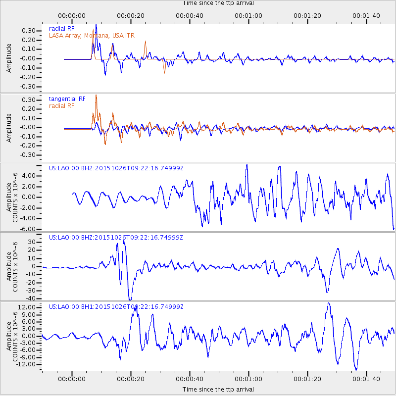
LAO LASA Array, Montana, USA - Earthquake Result Viewer
*The percent match for this event was below the threshold and hence no stack was calculated.
| Earthquake location: |
Hindu Kush Region, Afghanistan |
| Earthquake latitude/longitude: |
36.4/70.7 |
| Earthquake time(UTC): |
2015/10/26 (299) 09:09:32 GMT |
| Earthquake Depth: |
212 km |
| Earthquake Magnitude: |
7.5 MWW, 7.5 MWB |
| Earthquake Catalog/Contributor: |
NEIC PDE/NEIC COMCAT |
|
| Network: |
US United States National Seismic Network |
| Station: |
LAO LASA Array, Montana, USA |
| Lat/Lon: |
46.69 N/106.22 W |
| Elevation: |
902 m |
|
| Distance: |
97.2 deg |
| Az: |
357.877 deg |
| Baz: |
2.487 deg |
| Ray Param: |
$rayparam |
*The percent match for this event was below the threshold and hence was not used in the summary stack. |
|
| Radial Match: |
92.73261 % |
| Radial Bump: |
260 |
| Transverse Match: |
83.4768 % |
| Transverse Bump: |
400 |
| SOD ConfigId: |
7422571 |
| Insert Time: |
2019-04-21 05:07:39.080 +0000 |
| GWidth: |
2.5 |
| Max Bumps: |
400 |
| Tol: |
0.001 |
|
Signal To Noise
| Channel | StoN | STA | LTA |
| US:LAO:00:BHZ:20151026T09:22:16.74999Z | 1.4686478 | 9.4517173E-7 | 6.4356595E-7 |
| US:LAO:00:BH1:20151026T09:22:16.74999Z | 1.0343068 | 7.9665324E-7 | 7.702292E-7 |
| US:LAO:00:BH2:20151026T09:22:16.74999Z | 0.3508119 | 3.1464518E-7 | 8.9690565E-7 |
| Arrivals |
| Ps | |
| PpPs | |
| PsPs/PpSs | |


