You are here: Home > Network List > UW - Pacific Northwest Regional Seismic Network Stations List
> Station MRBL Marblemount, WA, USA > Earthquake Result Viewer
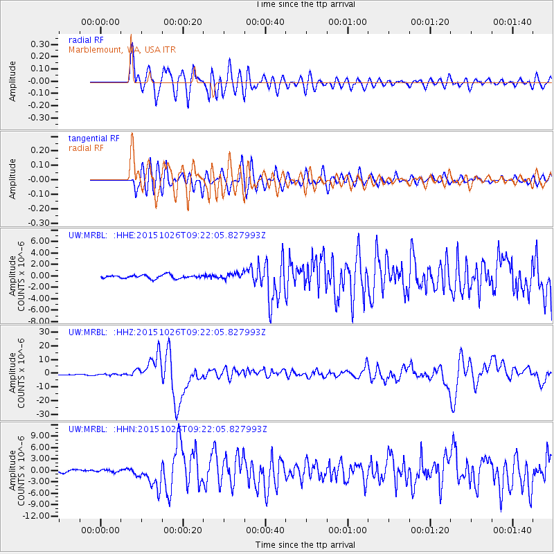
MRBL Marblemount, WA, USA - Earthquake Result Viewer
*The percent match for this event was below the threshold and hence no stack was calculated.
| Earthquake location: |
Hindu Kush Region, Afghanistan |
| Earthquake latitude/longitude: |
36.4/70.7 |
| Earthquake time(UTC): |
2015/10/26 (299) 09:09:32 GMT |
| Earthquake Depth: |
212 km |
| Earthquake Magnitude: |
7.5 MWW, 7.5 MWB |
| Earthquake Catalog/Contributor: |
NEIC PDE/NEIC COMCAT |
|
| Network: |
UW Pacific Northwest Regional Seismic Network |
| Station: |
MRBL Marblemount, WA, USA |
| Lat/Lon: |
48.52 N/121.48 W |
| Elevation: |
75 m |
|
| Distance: |
94.7 deg |
| Az: |
8.105 deg |
| Baz: |
350.154 deg |
| Ray Param: |
$rayparam |
*The percent match for this event was below the threshold and hence was not used in the summary stack. |
|
| Radial Match: |
90.90914 % |
| Radial Bump: |
400 |
| Transverse Match: |
83.812416 % |
| Transverse Bump: |
400 |
| SOD ConfigId: |
7422571 |
| Insert Time: |
2019-04-21 05:07:46.566 +0000 |
| GWidth: |
2.5 |
| Max Bumps: |
400 |
| Tol: |
0.001 |
|
Signal To Noise
| Channel | StoN | STA | LTA |
| UW:MRBL: :HHZ:20151026T09:22:05.827993Z | 1.4467134 | 5.1204626E-7 | 3.539376E-7 |
| UW:MRBL: :HHN:20151026T09:22:05.827993Z | 0.8769374 | 3.3314862E-7 | 3.7990011E-7 |
| UW:MRBL: :HHE:20151026T09:22:05.827993Z | 0.61448634 | 1.972064E-7 | 3.2092885E-7 |
| Arrivals |
| Ps | |
| PpPs | |
| PsPs/PpSs | |


