You are here: Home > Network List > US - United States National Seismic Network Stations List
> Station DGMT Dagmar, Montana, USA > Earthquake Result Viewer
DGMT Dagmar, Montana, USA - Earthquake Result Viewer
*The percent match for this event was below the threshold and hence no stack was calculated.
| Earthquake location: |
Bonin Islands, Japan Region |
| Earthquake latitude/longitude: |
27.8/140.5 |
| Earthquake time(UTC): |
2015/05/30 (150) 11:23:02 GMT |
| Earthquake Depth: |
678 km |
| Earthquake Magnitude: |
7.8 MWP, 8.5 MI |
| Earthquake Catalog/Contributor: |
NEIC PDE/NEIC COMCAT |
|
| Network: |
US United States National Seismic Network |
| Station: |
DGMT Dagmar, Montana, USA |
| Lat/Lon: |
48.47 N/104.20 W |
| Elevation: |
0.0 m |
|
| Distance: |
84.6 deg |
| Az: |
37.18 deg |
| Baz: |
306.467 deg |
| Ray Param: |
$rayparam |
*The percent match for this event was below the threshold and hence was not used in the summary stack. |
|
| Radial Match: |
93.92404 % |
| Radial Bump: |
400 |
| Transverse Match: |
83.89059 % |
| Transverse Bump: |
400 |
| SOD ConfigId: |
976571 |
| Insert Time: |
2015-06-13 11:30:30.669 +0000 |
| GWidth: |
2.5 |
| Max Bumps: |
400 |
| Tol: |
0.001 |
|
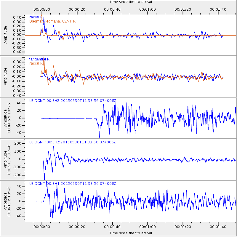
Signal To Noise
| Channel | StoN | STA | LTA |
| US:DGMT:00:BHZ:20150530T11:33:56.074006Z | 119.91088 | 8.336673E-5 | 6.9523907E-7 |
| US:DGMT:00:BH1:20150530T11:33:56.074006Z | 52.197296 | 2.1125448E-5 | 4.0472307E-7 |
| US:DGMT:00:BH2:20150530T11:33:56.074006Z | 53.048306 | 1.8787916E-5 | 3.5416622E-7 |
| Arrivals |
| Ps | |
| PpPs | |
| PsPs/PpSs | |


