You are here: Home > Network List > TA - USArray Transportable Network (new EarthScope stations) Stations List
> Station A21K Barrow, AK, USA > Earthquake Result Viewer
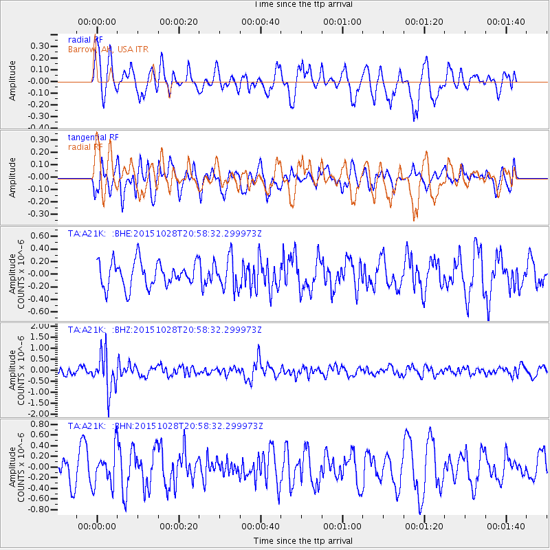
A21K Barrow, AK, USA - Earthquake Result Viewer
*The percent match for this event was below the threshold and hence no stack was calculated.
| Earthquake location: |
Santa Cruz Islands |
| Earthquake latitude/longitude: |
-11.0/166.4 |
| Earthquake time(UTC): |
2015/10/28 (301) 20:46:41 GMT |
| Earthquake Depth: |
152 km |
| Earthquake Magnitude: |
5.8 MWB |
| Earthquake Catalog/Contributor: |
NEIC PDE/NEIC COMCAT |
|
| Network: |
TA USArray Transportable Network (new EarthScope stations) |
| Station: |
A21K Barrow, AK, USA |
| Lat/Lon: |
71.32 N/156.62 W |
| Elevation: |
577 m |
|
| Distance: |
85.8 deg |
| Az: |
11.213 deg |
| Baz: |
216.345 deg |
| Ray Param: |
$rayparam |
*The percent match for this event was below the threshold and hence was not used in the summary stack. |
|
| Radial Match: |
68.87953 % |
| Radial Bump: |
400 |
| Transverse Match: |
48.12333 % |
| Transverse Bump: |
400 |
| SOD ConfigId: |
7422571 |
| Insert Time: |
2019-04-21 05:13:43.040 +0000 |
| GWidth: |
2.5 |
| Max Bumps: |
400 |
| Tol: |
0.001 |
|
Signal To Noise
| Channel | StoN | STA | LTA |
| TA:A21K: :BHZ:20151028T20:58:32.299973Z | 4.141186 | 8.7102455E-7 | 2.1033215E-7 |
| TA:A21K: :BHN:20151028T20:58:32.299973Z | 1.7411758 | 3.3012245E-7 | 1.8959743E-7 |
| TA:A21K: :BHE:20151028T20:58:32.299973Z | 1.2488468 | 2.524508E-7 | 2.0214715E-7 |
| Arrivals |
| Ps | |
| PpPs | |
| PsPs/PpSs | |


