You are here: Home > Network List > TA - USArray Transportable Network (new EarthScope stations) Stations List
> Station I23K Minto, Yukon-Koyukuk, AK, USA > Earthquake Result Viewer
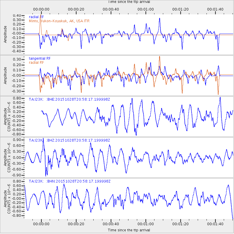
I23K Minto, Yukon-Koyukuk, AK, USA - Earthquake Result Viewer
*The percent match for this event was below the threshold and hence no stack was calculated.
| Earthquake location: |
Santa Cruz Islands |
| Earthquake latitude/longitude: |
-11.0/166.4 |
| Earthquake time(UTC): |
2015/10/28 (301) 20:46:41 GMT |
| Earthquake Depth: |
152 km |
| Earthquake Magnitude: |
5.8 MWB |
| Earthquake Catalog/Contributor: |
NEIC PDE/NEIC COMCAT |
|
| Network: |
TA USArray Transportable Network (new EarthScope stations) |
| Station: |
I23K Minto, Yukon-Koyukuk, AK, USA |
| Lat/Lon: |
65.15 N/149.36 W |
| Elevation: |
149 m |
|
| Distance: |
82.8 deg |
| Az: |
17.297 deg |
| Baz: |
223.696 deg |
| Ray Param: |
$rayparam |
*The percent match for this event was below the threshold and hence was not used in the summary stack. |
|
| Radial Match: |
54.797543 % |
| Radial Bump: |
365 |
| Transverse Match: |
35.75745 % |
| Transverse Bump: |
294 |
| SOD ConfigId: |
7422571 |
| Insert Time: |
2019-04-21 05:13:50.381 +0000 |
| GWidth: |
2.5 |
| Max Bumps: |
400 |
| Tol: |
0.001 |
|
Signal To Noise
| Channel | StoN | STA | LTA |
| TA:I23K: :BHZ:20151028T20:58:17.199998Z | 3.1699853 | 5.065967E-7 | 1.5981043E-7 |
| TA:I23K: :BHN:20151028T20:58:17.199998Z | 0.84192246 | 2.8487995E-7 | 3.3836838E-7 |
| TA:I23K: :BHE:20151028T20:58:17.199998Z | 0.9719281 | 2.1533758E-7 | 2.2155709E-7 |
| Arrivals |
| Ps | |
| PpPs | |
| PsPs/PpSs | |


