You are here: Home > Network List > UW - Pacific Northwest Regional Seismic Network Stations List
> Station UMAT Pilot Rock, OR, USA > Earthquake Result Viewer
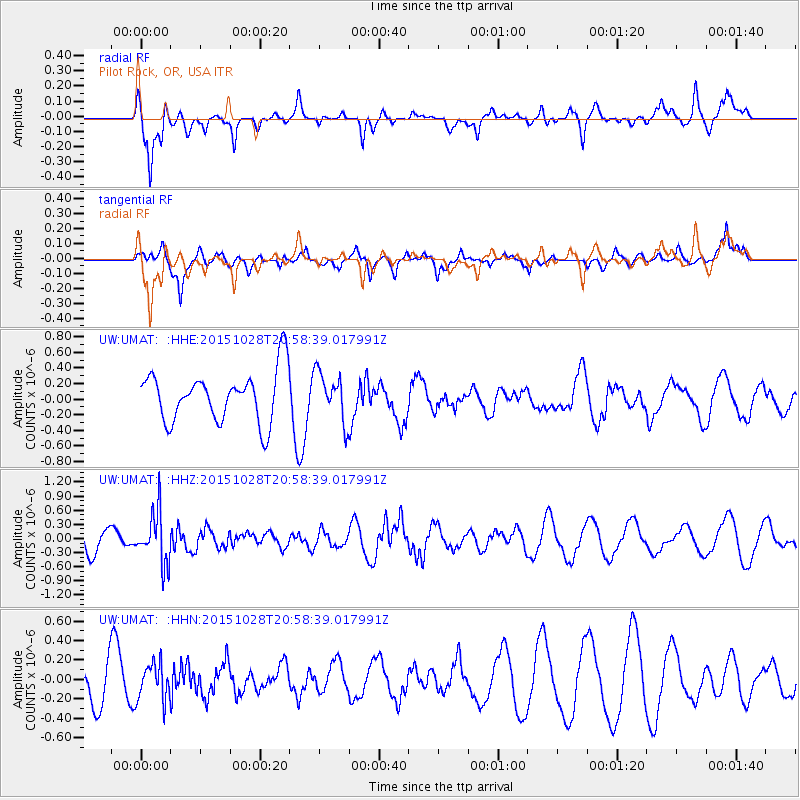
UMAT Pilot Rock, OR, USA - Earthquake Result Viewer
*The percent match for this event was below the threshold and hence no stack was calculated.
| Earthquake location: |
Santa Cruz Islands |
| Earthquake latitude/longitude: |
-11.0/166.4 |
| Earthquake time(UTC): |
2015/10/28 (301) 20:46:41 GMT |
| Earthquake Depth: |
152 km |
| Earthquake Magnitude: |
5.8 MWB |
| Earthquake Catalog/Contributor: |
NEIC PDE/NEIC COMCAT |
|
| Network: |
UW Pacific Northwest Regional Seismic Network |
| Station: |
UMAT Pilot Rock, OR, USA |
| Lat/Lon: |
45.29 N/118.96 W |
| Elevation: |
1318 m |
|
| Distance: |
87.2 deg |
| Az: |
42.968 deg |
| Baz: |
251.463 deg |
| Ray Param: |
$rayparam |
*The percent match for this event was below the threshold and hence was not used in the summary stack. |
|
| Radial Match: |
71.981766 % |
| Radial Bump: |
328 |
| Transverse Match: |
47.284637 % |
| Transverse Bump: |
400 |
| SOD ConfigId: |
7422571 |
| Insert Time: |
2019-04-21 05:14:43.040 +0000 |
| GWidth: |
2.5 |
| Max Bumps: |
400 |
| Tol: |
0.001 |
|
Signal To Noise
| Channel | StoN | STA | LTA |
| UW:UMAT: :HHZ:20151028T20:58:39.017991Z | 2.0735338 | 5.37753E-7 | 2.5934133E-7 |
| UW:UMAT: :HHN:20151028T20:58:39.017991Z | 1.3094424 | 1.8641038E-7 | 1.4235859E-7 |
| UW:UMAT: :HHE:20151028T20:58:39.017991Z | 0.9876888 | 3.2075013E-7 | 3.2474819E-7 |
| Arrivals |
| Ps | |
| PpPs | |
| PsPs/PpSs | |


