You are here: Home > Network List > UU - University of Utah Regional Network Stations List
> Station ASI2 Darling Creek, Challis, ID, USA > Earthquake Result Viewer
ASI2 Darling Creek, Challis, ID, USA - Earthquake Result Viewer
| Earthquake location: |
Bonin Islands, Japan Region |
| Earthquake latitude/longitude: |
27.8/140.5 |
| Earthquake time(UTC): |
2015/05/30 (150) 11:23:02 GMT |
| Earthquake Depth: |
678 km |
| Earthquake Magnitude: |
7.8 MWP, 8.5 MI |
| Earthquake Catalog/Contributor: |
NEIC PDE/NEIC COMCAT |
|
| Network: |
UU University of Utah Regional Network |
| Station: |
ASI2 Darling Creek, Challis, ID, USA |
| Lat/Lon: |
44.57 N/114.26 W |
| Elevation: |
1600 m |
|
| Distance: |
80.9 deg |
| Az: |
44.294 deg |
| Baz: |
300.077 deg |
| Ray Param: |
0.045803092 |
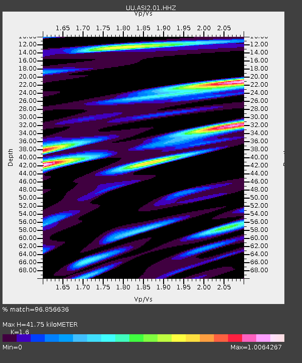
| Estimated Moho Depth: |
41.75 km |
| Estimated Crust Vp/Vs: |
1.60 |
| Assumed Crust Vp: |
6.577 km/s |
| Estimated Crust Vs: |
4.111 km/s |
| Estimated Crust Poisson's Ratio: |
0.18 |
|
| Radial Match: |
96.856636 % |
| Radial Bump: |
400 |
| Transverse Match: |
96.40637 % |
| Transverse Bump: |
400 |
| SOD ConfigId: |
976571 |
| Insert Time: |
2015-06-13 11:32:07.491 +0000 |
| GWidth: |
2.5 |
| Max Bumps: |
400 |
| Tol: |
0.001 |
|

Signal To Noise
| Channel | StoN | STA | LTA |
| UU:ASI2:01:HHZ:20150530T11:33:37.858979Z | 750.0201 | 3.8813987E-6 | 5.17506E-9 |
| UU:ASI2:01:HHN:20150530T11:33:37.858979Z | 142.58664 | 8.451383E-7 | 5.927191E-9 |
| UU:ASI2:01:HHE:20150530T11:33:37.858979Z | 204.12154 | 1.3737599E-6 | 6.7301076E-9 |
| Arrivals |
| Ps | 3.9 SECOND |
| PpPs | 16 SECOND |
| PsPs/PpSs | 20 SECOND |


