You are here: Home > Network List > ND - New CaleDonia Broadband Seismic Network Stations List
> Station KOUNC Koumac, New Caledonia > Earthquake Result Viewer
KOUNC Koumac, New Caledonia - Earthquake Result Viewer
| Earthquake location: |
Rat Islands, Aleutian Islands |
| Earthquake latitude/longitude: |
51.8/178.5 |
| Earthquake time(UTC): |
2015/10/29 (302) 02:49:28 GMT |
| Earthquake Depth: |
88 km |
| Earthquake Magnitude: |
5.6 MB |
| Earthquake Catalog/Contributor: |
NEIC PDE/NEIC COMCAT |
|
| Network: |
ND New CaleDonia Broadband Seismic Network |
| Station: |
KOUNC Koumac, New Caledonia |
| Lat/Lon: |
20.55 S/164.29 E |
| Elevation: |
88 m |
|
| Distance: |
73.1 deg |
| Az: |
193.928 deg |
| Baz: |
9.174 deg |
| Ray Param: |
0.053007267 |
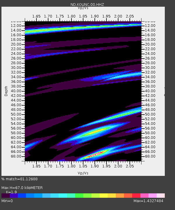
| Estimated Moho Depth: |
67.0 km |
| Estimated Crust Vp/Vs: |
1.90 |
| Assumed Crust Vp: |
5.14 km/s |
| Estimated Crust Vs: |
2.705 km/s |
| Estimated Crust Poisson's Ratio: |
0.31 |
|
| Radial Match: |
81.12688 % |
| Radial Bump: |
400 |
| Transverse Match: |
64.91372 % |
| Transverse Bump: |
400 |
| SOD ConfigId: |
7422571 |
| Insert Time: |
2019-04-21 05:22:21.503 +0000 |
| GWidth: |
2.5 |
| Max Bumps: |
400 |
| Tol: |
0.001 |
|
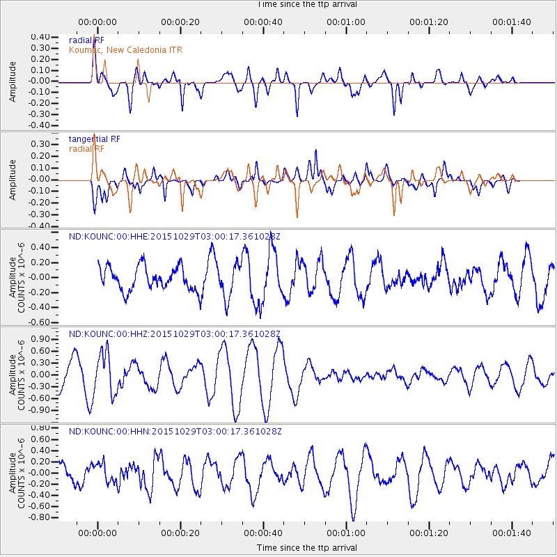
Signal To Noise
| Channel | StoN | STA | LTA |
| ND:KOUNC:00:HHZ:20151029T03:00:17.361028Z | 1.9533958 | 5.1912394E-7 | 2.657546E-7 |
| ND:KOUNC:00:HHN:20151029T03:00:17.361028Z | 0.874871 | 1.7272548E-7 | 1.9742964E-7 |
| ND:KOUNC:00:HHE:20151029T03:00:17.361028Z | 1.773432 | 2.7658E-7 | 1.5595748E-7 |
| Arrivals |
| Ps | 12 SECOND |
| PpPs | 37 SECOND |
| PsPs/PpSs | 49 SECOND |


