You are here: Home > Network List > TA - USArray Transportable Network (new EarthScope stations) Stations List
> Station A36M Sachs Harbour, NT, CAN > Earthquake Result Viewer
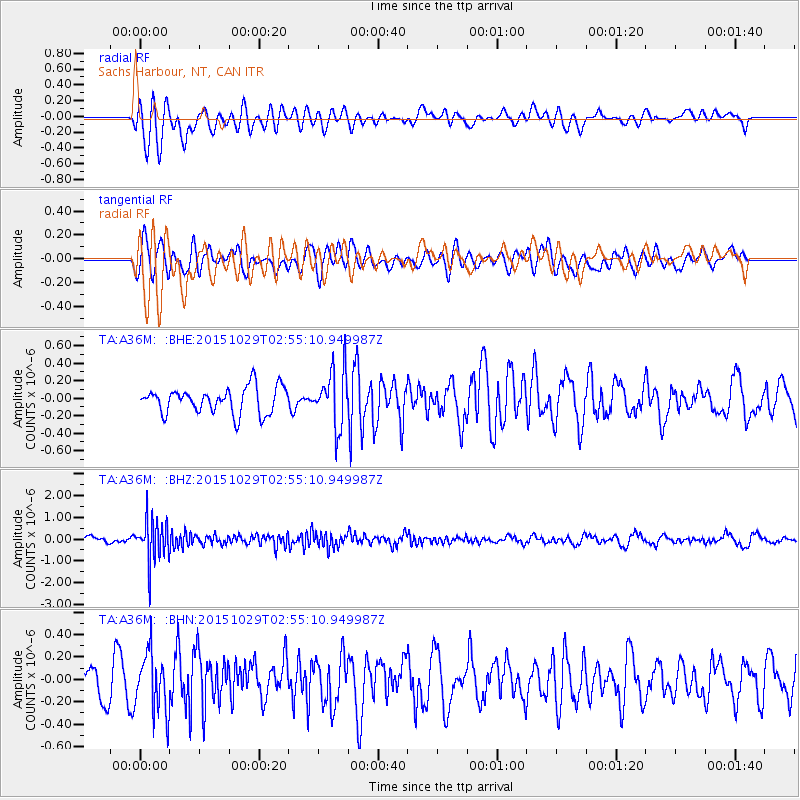
A36M Sachs Harbour, NT, CAN - Earthquake Result Viewer
*The percent match for this event was below the threshold and hence no stack was calculated.
| Earthquake location: |
Rat Islands, Aleutian Islands |
| Earthquake latitude/longitude: |
51.8/178.5 |
| Earthquake time(UTC): |
2015/10/29 (302) 02:49:28 GMT |
| Earthquake Depth: |
88 km |
| Earthquake Magnitude: |
5.6 MB |
| Earthquake Catalog/Contributor: |
NEIC PDE/NEIC COMCAT |
|
| Network: |
TA USArray Transportable Network (new EarthScope stations) |
| Station: |
A36M Sachs Harbour, NT, CAN |
| Lat/Lon: |
71.99 N/125.25 W |
| Elevation: |
32 m |
|
| Distance: |
31.5 deg |
| Az: |
29.65 deg |
| Baz: |
260.763 deg |
| Ray Param: |
$rayparam |
*The percent match for this event was below the threshold and hence was not used in the summary stack. |
|
| Radial Match: |
55.357285 % |
| Radial Bump: |
400 |
| Transverse Match: |
56.31108 % |
| Transverse Bump: |
400 |
| SOD ConfigId: |
7422571 |
| Insert Time: |
2019-04-21 05:24:24.090 +0000 |
| GWidth: |
2.5 |
| Max Bumps: |
400 |
| Tol: |
0.001 |
|
Signal To Noise
| Channel | StoN | STA | LTA |
| TA:A36M: :BHZ:20151029T02:55:10.949987Z | 4.739919 | 9.64091E-7 | 2.0339817E-7 |
| TA:A36M: :BHN:20151029T02:55:10.949987Z | 1.7925522 | 2.6561514E-7 | 1.4817707E-7 |
| TA:A36M: :BHE:20151029T02:55:10.949987Z | 2.409906 | 3.631987E-7 | 1.5071073E-7 |
| Arrivals |
| Ps | |
| PpPs | |
| PsPs/PpSs | |


