You are here: Home > Network List > TA - USArray Transportable Network (new EarthScope stations) Stations List
> Station X43A Marvell, AR, USA > Earthquake Result Viewer
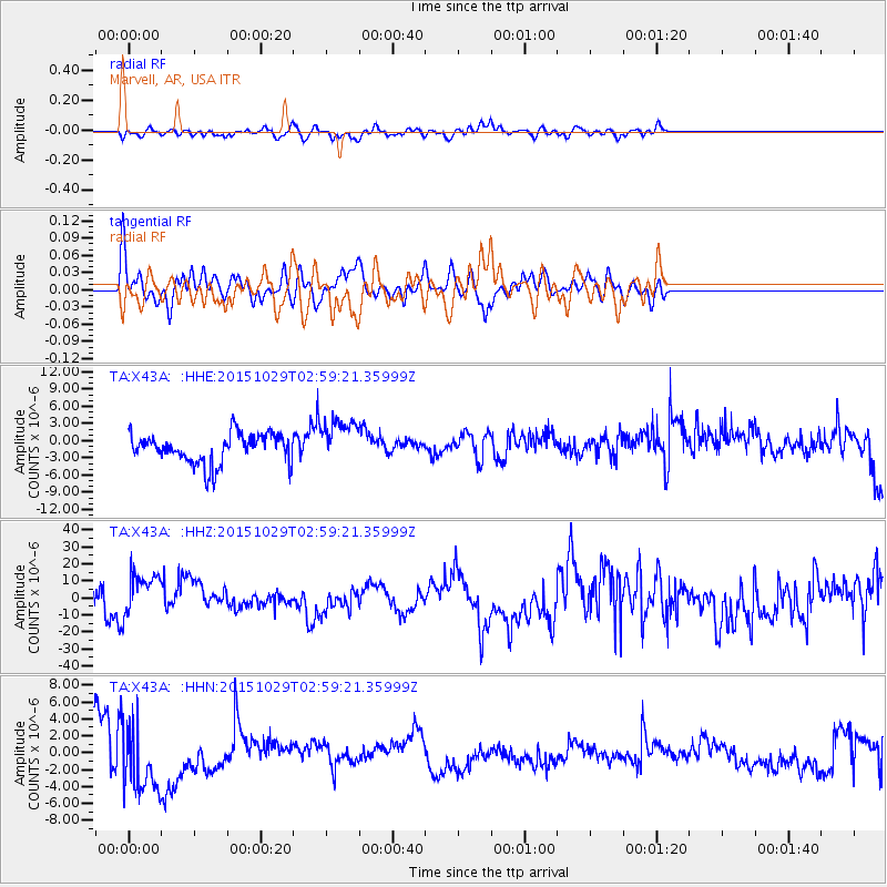
X43A Marvell, AR, USA - Earthquake Result Viewer
*The percent match for this event was below the threshold and hence no stack was calculated.
| Earthquake location: |
Rat Islands, Aleutian Islands |
| Earthquake latitude/longitude: |
51.8/178.5 |
| Earthquake time(UTC): |
2015/10/29 (302) 02:49:28 GMT |
| Earthquake Depth: |
88 km |
| Earthquake Magnitude: |
5.6 MB |
| Earthquake Catalog/Contributor: |
NEIC PDE/NEIC COMCAT |
|
| Network: |
TA USArray Transportable Network (new EarthScope stations) |
| Station: |
X43A Marvell, AR, USA |
| Lat/Lon: |
34.52 N/90.88 W |
| Elevation: |
53 m |
|
| Distance: |
64.1 deg |
| Az: |
66.619 deg |
| Baz: |
316.368 deg |
| Ray Param: |
$rayparam |
*The percent match for this event was below the threshold and hence was not used in the summary stack. |
|
| Radial Match: |
57.12777 % |
| Radial Bump: |
400 |
| Transverse Match: |
58.2673 % |
| Transverse Bump: |
400 |
| SOD ConfigId: |
7422571 |
| Insert Time: |
2019-04-21 05:24:46.013 +0000 |
| GWidth: |
2.5 |
| Max Bumps: |
400 |
| Tol: |
0.001 |
|
Signal To Noise
| Channel | StoN | STA | LTA |
| TA:X43A: :HHZ:20151029T02:59:21.35999Z | 1.6231072 | 1.3547678E-5 | 8.346755E-6 |
| TA:X43A: :HHN:20151029T02:59:21.35999Z | 1.0125902 | 4.071468E-6 | 4.0208447E-6 |
| TA:X43A: :HHE:20151029T02:59:21.35999Z | 1.5532724 | 3.969386E-6 | 2.5554991E-6 |
| Arrivals |
| Ps | |
| PpPs | |
| PsPs/PpSs | |


