You are here: Home > Network List > US - United States National Seismic Network Stations List
> Station ERPA Erie, Pennsylvania, USA > Earthquake Result Viewer
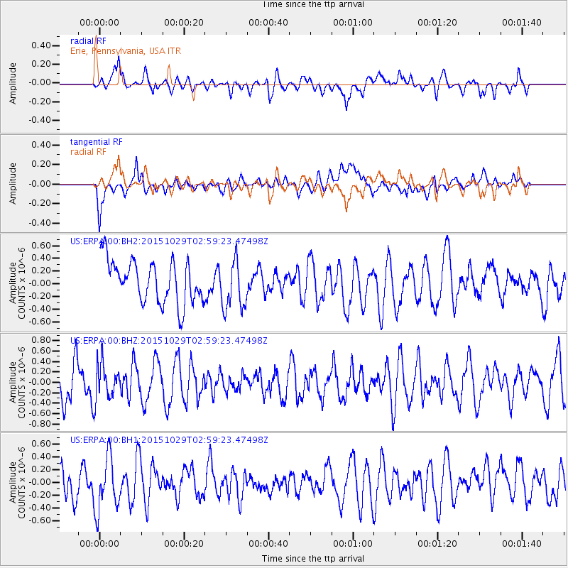
ERPA Erie, Pennsylvania, USA - Earthquake Result Viewer
*The percent match for this event was below the threshold and hence no stack was calculated.
| Earthquake location: |
Rat Islands, Aleutian Islands |
| Earthquake latitude/longitude: |
51.8/178.5 |
| Earthquake time(UTC): |
2015/10/29 (302) 02:49:28 GMT |
| Earthquake Depth: |
88 km |
| Earthquake Magnitude: |
5.6 MB |
| Earthquake Catalog/Contributor: |
NEIC PDE/NEIC COMCAT |
|
| Network: |
US United States National Seismic Network |
| Station: |
ERPA Erie, Pennsylvania, USA |
| Lat/Lon: |
42.12 N/79.99 W |
| Elevation: |
306 m |
|
| Distance: |
64.4 deg |
| Az: |
53.933 deg |
| Baz: |
317.593 deg |
| Ray Param: |
$rayparam |
*The percent match for this event was below the threshold and hence was not used in the summary stack. |
|
| Radial Match: |
54.012787 % |
| Radial Bump: |
400 |
| Transverse Match: |
50.30874 % |
| Transverse Bump: |
400 |
| SOD ConfigId: |
7422571 |
| Insert Time: |
2019-04-21 05:25:10.464 +0000 |
| GWidth: |
2.5 |
| Max Bumps: |
400 |
| Tol: |
0.001 |
|
Signal To Noise
| Channel | StoN | STA | LTA |
| US:ERPA:00:BHZ:20151029T02:59:23.47498Z | 0.9489523 | 3.1180753E-7 | 3.2858082E-7 |
| US:ERPA:00:BH1:20151029T02:59:23.47498Z | 1.7050786 | 4.1565178E-7 | 2.437728E-7 |
| US:ERPA:00:BH2:20151029T02:59:23.47498Z | 1.0499873 | 3.3916896E-7 | 3.2302194E-7 |
| Arrivals |
| Ps | |
| PpPs | |
| PsPs/PpSs | |


