You are here: Home > Network List > IC - New China Digital Seismograph Network Stations List
> Station BJT Baijiatuan, Beijing, China > Earthquake Result Viewer
BJT Baijiatuan, Beijing, China - Earthquake Result Viewer
| Earthquake location: |
Irian Jaya Region, Indonesia |
| Earthquake latitude/longitude: |
-0.9/137.0 |
| Earthquake time(UTC): |
1996/02/17 (048) 05:59:29 GMT |
| Earthquake Depth: |
33 km |
| Earthquake Magnitude: |
6.5 MB, 8.1 MS, 7.9 UNKNOWN |
| Earthquake Catalog/Contributor: |
WHDF/NEIC |
|
| Network: |
IC New China Digital Seismograph Network |
| Station: |
BJT Baijiatuan, Beijing, China |
| Lat/Lon: |
40.02 N/116.17 E |
| Elevation: |
197 m |
|
| Distance: |
45.0 deg |
| Az: |
337.254 deg |
| Baz: |
149.775 deg |
| Ray Param: |
0.0714925 |
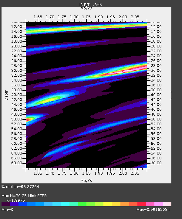
| Estimated Moho Depth: |
30.25 km |
| Estimated Crust Vp/Vs: |
2.00 |
| Assumed Crust Vp: |
6.464 km/s |
| Estimated Crust Vs: |
3.236 km/s |
| Estimated Crust Poisson's Ratio: |
0.33 |
|
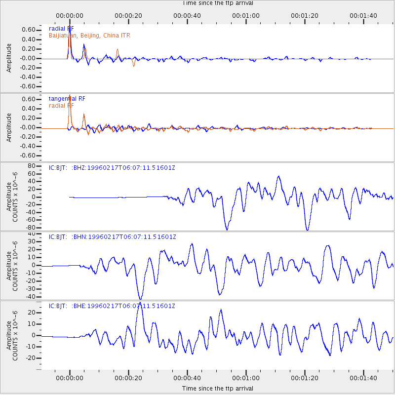
| Radial Match: |
98.37264 % |
| Radial Bump: |
225 |
| Transverse Match: |
91.42305 % |
| Transverse Bump: |
400 |
| SOD ConfigId: |
6273 |
| Insert Time: |
2010-03-04 21:25:08.872 +0000 |
| GWidth: |
2.5 |
| Max Bumps: |
400 |
| Tol: |
0.001 |
|
Signal To Noise
| Channel | StoN | STA | LTA |
| IC:BJT: :BHN:19960217T06:07:11.51601Z | 5.472924 | 1.0492317E-6 | 1.917132E-7 |
| IC:BJT: :BHE:19960217T06:07:11.51601Z | 4.3784094 | 7.0728487E-7 | 1.6153922E-7 |
| IC:BJT: :BHZ:19960217T06:07:11.51601Z | 6.275796 | 2.150101E-6 | 3.4260214E-7 |
| Arrivals |
| Ps | 4.9 SECOND |
| PpPs | 13 SECOND |
| PsPs/PpSs | 18 SECOND |


