You are here: Home > Network List > GS - US Geological Survey Networks Stations List
> Station DEC09 Decatur Surface Seismic Site, Decatur, IL, USA > Earthquake Result Viewer
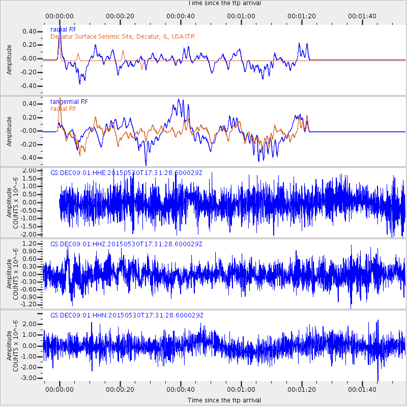
DEC09 Decatur Surface Seismic Site, Decatur, IL, USA - Earthquake Result Viewer
*The percent match for this event was below the threshold and hence no stack was calculated.
| Earthquake location: |
Tonga Islands |
| Earthquake latitude/longitude: |
-15.7/-173.3 |
| Earthquake time(UTC): |
2015/05/30 (150) 17:18:39 GMT |
| Earthquake Depth: |
51 km |
| Earthquake Magnitude: |
5.8 MB |
| Earthquake Catalog/Contributor: |
NEIC PDE/NEIC COMCAT |
|
| Network: |
GS US Geological Survey Networks |
| Station: |
DEC09 Decatur Surface Seismic Site, Decatur, IL, USA |
| Lat/Lon: |
39.87 N/88.92 W |
| Elevation: |
207 m |
|
| Distance: |
95.7 deg |
| Az: |
50.33 deg |
| Baz: |
254.407 deg |
| Ray Param: |
$rayparam |
*The percent match for this event was below the threshold and hence was not used in the summary stack. |
|
| Radial Match: |
47.14027 % |
| Radial Bump: |
286 |
| Transverse Match: |
60.52652 % |
| Transverse Bump: |
361 |
| SOD ConfigId: |
976571 |
| Insert Time: |
2015-06-13 17:55:31.050 +0000 |
| GWidth: |
2.5 |
| Max Bumps: |
400 |
| Tol: |
0.001 |
|
Signal To Noise
| Channel | StoN | STA | LTA |
| GS:DEC09:01:HHZ:20150530T17:31:28.600029Z | 1.674517 | 4.8828394E-7 | 2.9159688E-7 |
| GS:DEC09:01:HHN:20150530T17:31:28.600029Z | 0.9069296 | 5.687312E-7 | 6.2709523E-7 |
| GS:DEC09:01:HHE:20150530T17:31:28.600029Z | 0.95840603 | 6.368406E-7 | 6.644789E-7 |
| Arrivals |
| Ps | |
| PpPs | |
| PsPs/PpSs | |


