You are here: Home > Network List > IC - New China Digital Seismograph Network Stations List
> Station BJT Baijiatuan, Beijing, China > Earthquake Result Viewer
BJT Baijiatuan, Beijing, China - Earthquake Result Viewer
| Earthquake location: |
South Of Fiji Islands |
| Earthquake latitude/longitude: |
-22.1/-176.8 |
| Earthquake time(UTC): |
1997/10/14 (287) 09:53:18 GMT |
| Earthquake Depth: |
167 km |
| Earthquake Magnitude: |
6.7 MB, 7.7 UNKNOWN, 7.4 ME |
| Earthquake Catalog/Contributor: |
WHDF/NEIC |
|
| Network: |
IC New China Digital Seismograph Network |
| Station: |
BJT Baijiatuan, Beijing, China |
| Lat/Lon: |
40.02 N/116.17 E |
| Elevation: |
197 m |
|
| Distance: |
87.8 deg |
| Az: |
314.949 deg |
| Baz: |
121.277 deg |
| Ray Param: |
0.04266302 |
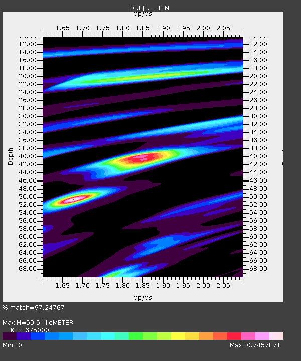
| Estimated Moho Depth: |
50.5 km |
| Estimated Crust Vp/Vs: |
1.68 |
| Assumed Crust Vp: |
6.464 km/s |
| Estimated Crust Vs: |
3.859 km/s |
| Estimated Crust Poisson's Ratio: |
0.22 |
|
| Radial Match: |
97.24767 % |
| Radial Bump: |
361 |
| Transverse Match: |
93.97332 % |
| Transverse Bump: |
342 |
| SOD ConfigId: |
6273 |
| Insert Time: |
2010-03-04 21:27:13.961 +0000 |
| GWidth: |
2.5 |
| Max Bumps: |
400 |
| Tol: |
0.001 |
|
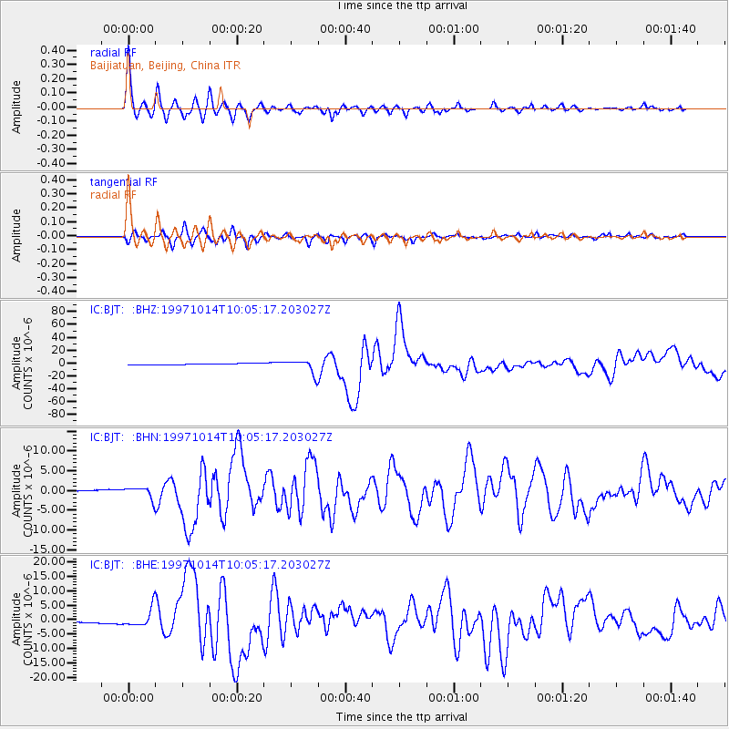
Signal To Noise
| Channel | StoN | STA | LTA |
| IC:BJT: :BHN:19971014T10:05:17.203027Z | 8.916504 | 1.5277221E-6 | 1.7133645E-7 |
| IC:BJT: :BHE:19971014T10:05:17.203027Z | 10.883641 | 3.3386173E-6 | 3.0675554E-7 |
| IC:BJT: :BHZ:19971014T10:05:17.203027Z | 11.248654 | 1.1142433E-5 | 9.90557E-7 |
| Arrivals |
| Ps | 5.4 SECOND |
| PpPs | 20 SECOND |
| PsPs/PpSs | 26 SECOND |


