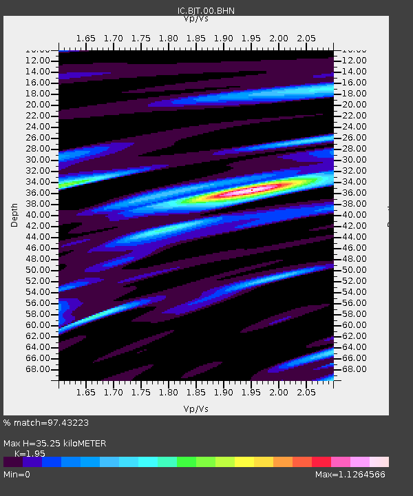
BJT Baijiatuan, Beijing, China - Earthquake Result Viewer

Earthquake location: Southern Sumatra, Indonesia
Earthquake latitude/longitude: -2.0/100.1
Earthquake time(UTC): 2007/09/20 (263) 08:31:14 GMT
Earthquake Depth: 30 km
Earthquake Magnitude: 6.3 MB, 6.8 MS, 6.7 MW, 6.3 ME
Earthquake Catalog/Contributor: WHDF/NEIC
Network: IC New China Digital Seismograph Network
Station: BJT Baijiatuan, Beijing, China
Lat/Lon: 40.02 N/116.17 E
Elevation: 197 m
Distance: 44.3 deg
Az: 17.667 deg
Baz: 203.263 deg
Ray Param: 0.07193546
Estimated Moho Depth: 35.25 km
Estimated Crust Vp/Vs: 1.95
Assumed Crust Vp: 6.464 km/s
Estimated Crust Vs: 3.315 km/s
Estimated Crust Poisson's Ratio: 0.32
Radial Match: 97.43223 %
Radial Bump: 390
Transverse Match: 91.25646 %
Transverse Bump: 400
SOD ConfigId: 2564
Insert Time: 2010-03-04 21:28:20.660 +0000
GWidth: 2.5
Max Bumps: 400
Tol: 0.001

Signal To Noise

ChannelStoNSTALTA
IC:BJT:00:BHN:20070920T08:38:51.061014Z8.0034597.561995E-79.4484086E-8
IC:BJT:00:BHE:20070920T08:38:51.061014Z2.07420183.1222697E-71.5052873E-7
IC:BJT:00:BHZ:20070920T08:38:51.061014Z11.1454071.6883868E-61.5148723E-7
Arrivals
Ps5.5 SECOND
PpPs15 SECOND
PsPs/PpSs21 SECOND