You are here: Home > Network List > II - Global Seismograph Network (GSN - IRIS/IDA) Stations List
> Station CMLA Cha de Macela, Sao Miguel Island, Azores > Earthquake Result Viewer
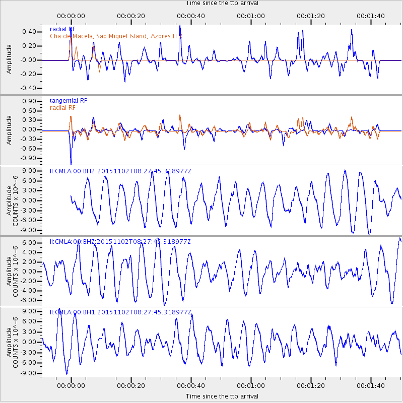
CMLA Cha de Macela, Sao Miguel Island, Azores - Earthquake Result Viewer
*The percent match for this event was below the threshold and hence no stack was calculated.
| Earthquake location: |
Andreanof Islands, Aleutian Is. |
| Earthquake latitude/longitude: |
51.7/-173.4 |
| Earthquake time(UTC): |
2015/11/02 (306) 08:15:34 GMT |
| Earthquake Depth: |
21 km |
| Earthquake Magnitude: |
5.9 MWP, 5.2 MI |
| Earthquake Catalog/Contributor: |
NEIC PDE/NEIC COMCAT |
|
| Network: |
II Global Seismograph Network (GSN - IRIS/IDA) |
| Station: |
CMLA Cha de Macela, Sao Miguel Island, Azores |
| Lat/Lon: |
37.76 N/25.52 W |
| Elevation: |
429 m |
|
| Distance: |
86.6 deg |
| Az: |
24.957 deg |
| Baz: |
340.63 deg |
| Ray Param: |
$rayparam |
*The percent match for this event was below the threshold and hence was not used in the summary stack. |
|
| Radial Match: |
60.67383 % |
| Radial Bump: |
400 |
| Transverse Match: |
72.480835 % |
| Transverse Bump: |
344 |
| SOD ConfigId: |
7422571 |
| Insert Time: |
2019-04-21 05:46:20.356 +0000 |
| GWidth: |
2.5 |
| Max Bumps: |
400 |
| Tol: |
0.001 |
|
Signal To Noise
| Channel | StoN | STA | LTA |
| II:CMLA:00:BHZ:20151102T08:27:45.318977Z | 1.6533512 | 3.3006957E-6 | 1.996367E-6 |
| II:CMLA:00:BH1:20151102T08:27:45.318977Z | 1.1353198 | 4.809786E-6 | 4.2365027E-6 |
| II:CMLA:00:BH2:20151102T08:27:45.318977Z | 1.4081106 | 6.0270013E-6 | 4.280205E-6 |
| Arrivals |
| Ps | |
| PpPs | |
| PsPs/PpSs | |


