You are here: Home > Network List > N4 - Central and EAstern US Network Stations List
> Station M44A Midewin, Midewin Nat. Tallgrass Prarie, IL, USA > Earthquake Result Viewer
M44A Midewin, Midewin Nat. Tallgrass Prarie, IL, USA - Earthquake Result Viewer
| Earthquake location: |
Andreanof Islands, Aleutian Is. |
| Earthquake latitude/longitude: |
51.7/-173.4 |
| Earthquake time(UTC): |
2015/11/02 (306) 08:15:34 GMT |
| Earthquake Depth: |
21 km |
| Earthquake Magnitude: |
5.9 MWP, 5.2 MI |
| Earthquake Catalog/Contributor: |
NEIC PDE/NEIC COMCAT |
|
| Network: |
N4 Central and EAstern US Network |
| Station: |
M44A Midewin, Midewin Nat. Tallgrass Prarie, IL, USA |
| Lat/Lon: |
41.39 N/88.04 W |
| Elevation: |
207 m |
|
| Distance: |
56.4 deg |
| Az: |
64.181 deg |
| Baz: |
311.816 deg |
| Ray Param: |
0.06412343 |
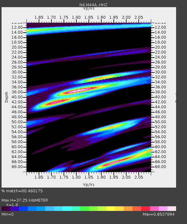
| Estimated Moho Depth: |
37.25 km |
| Estimated Crust Vp/Vs: |
1.80 |
| Assumed Crust Vp: |
6.498 km/s |
| Estimated Crust Vs: |
3.61 km/s |
| Estimated Crust Poisson's Ratio: |
0.28 |
|
| Radial Match: |
80.460175 % |
| Radial Bump: |
362 |
| Transverse Match: |
68.92246 % |
| Transverse Bump: |
385 |
| SOD ConfigId: |
7422571 |
| Insert Time: |
2019-04-21 05:48:27.484 +0000 |
| GWidth: |
2.5 |
| Max Bumps: |
400 |
| Tol: |
0.001 |
|

Signal To Noise
| Channel | StoN | STA | LTA |
| N4:M44A: :HHZ:20151102T08:24:43.529976Z | 4.4798126 | 1.0579183E-6 | 2.3615236E-7 |
| N4:M44A: :HHN:20151102T08:24:43.529976Z | 1.2029672 | 5.542114E-7 | 4.607037E-7 |
| N4:M44A: :HHE:20151102T08:24:43.529976Z | 1.3474948 | 6.1924703E-7 | 4.595543E-7 |
| Arrivals |
| Ps | 4.8 SECOND |
| PpPs | 15 SECOND |
| PsPs/PpSs | 20 SECOND |


