You are here: Home > Network List > TA - USArray Transportable Network (new EarthScope stations) Stations List
> Station M54A Oil Creek State Park, Oil City, PA, USA > Earthquake Result Viewer
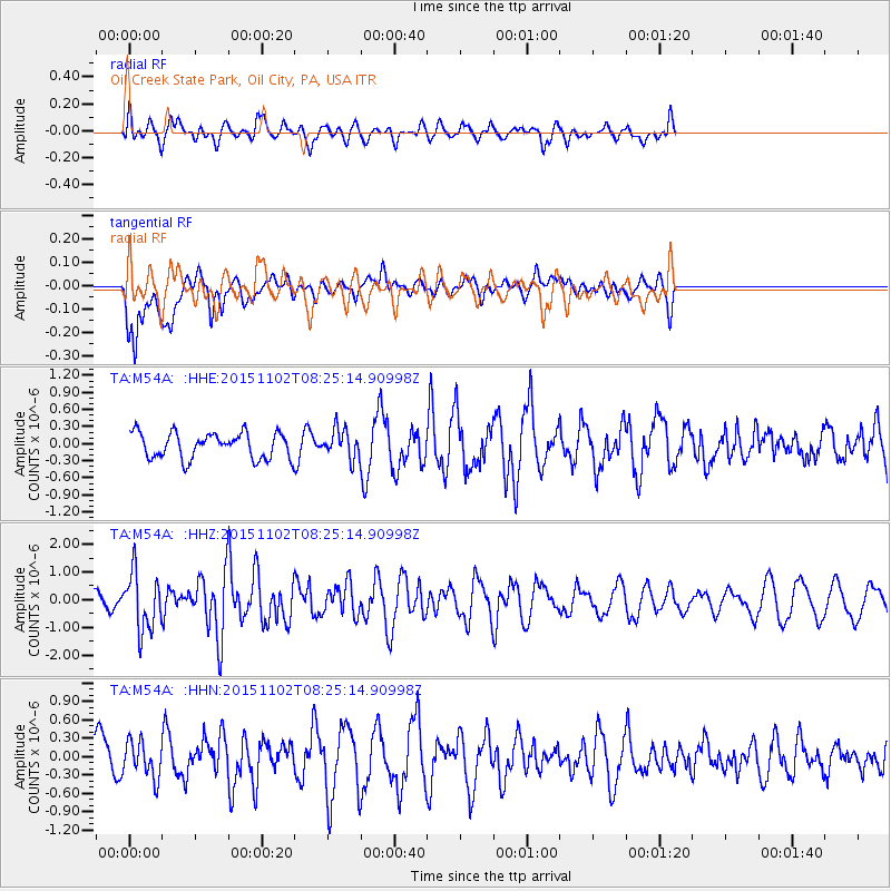
M54A Oil Creek State Park, Oil City, PA, USA - Earthquake Result Viewer
*The percent match for this event was below the threshold and hence no stack was calculated.
| Earthquake location: |
Andreanof Islands, Aleutian Is. |
| Earthquake latitude/longitude: |
51.7/-173.4 |
| Earthquake time(UTC): |
2015/11/02 (306) 08:15:34 GMT |
| Earthquake Depth: |
21 km |
| Earthquake Magnitude: |
5.9 MWP, 5.2 MI |
| Earthquake Catalog/Contributor: |
NEIC PDE/NEIC COMCAT |
|
| Network: |
TA USArray Transportable Network (new EarthScope stations) |
| Station: |
M54A Oil Creek State Park, Oil City, PA, USA |
| Lat/Lon: |
41.51 N/79.66 W |
| Elevation: |
488 m |
|
| Distance: |
60.9 deg |
| Az: |
59.031 deg |
| Baz: |
314.667 deg |
| Ray Param: |
$rayparam |
*The percent match for this event was below the threshold and hence was not used in the summary stack. |
|
| Radial Match: |
57.171432 % |
| Radial Bump: |
400 |
| Transverse Match: |
71.461075 % |
| Transverse Bump: |
400 |
| SOD ConfigId: |
7422571 |
| Insert Time: |
2019-04-21 05:51:43.904 +0000 |
| GWidth: |
2.5 |
| Max Bumps: |
400 |
| Tol: |
0.001 |
|
Signal To Noise
| Channel | StoN | STA | LTA |
| TA:M54A: :HHZ:20151102T08:25:14.90998Z | 5.212425 | 1.0257504E-6 | 1.9678947E-7 |
| TA:M54A: :HHN:20151102T08:25:14.90998Z | 0.9998248 | 2.9115822E-7 | 2.912092E-7 |
| TA:M54A: :HHE:20151102T08:25:14.90998Z | 1.2513556 | 2.8811354E-7 | 2.3024114E-7 |
| Arrivals |
| Ps | |
| PpPs | |
| PsPs/PpSs | |


