You are here: Home > Network List > TA - USArray Transportable Network (new EarthScope stations) Stations List
> Station Q61A Milford, DE, USA > Earthquake Result Viewer
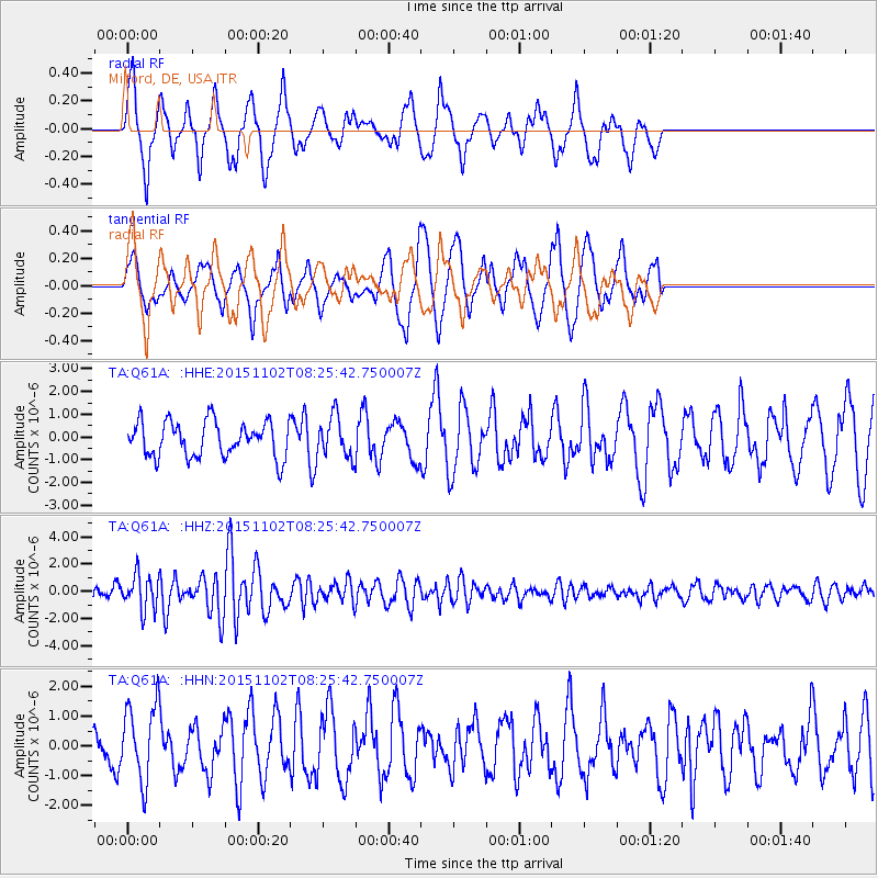
Q61A Milford, DE, USA - Earthquake Result Viewer
*The percent match for this event was below the threshold and hence no stack was calculated.
| Earthquake location: |
Andreanof Islands, Aleutian Is. |
| Earthquake latitude/longitude: |
51.7/-173.4 |
| Earthquake time(UTC): |
2015/11/02 (306) 08:15:34 GMT |
| Earthquake Depth: |
21 km |
| Earthquake Magnitude: |
5.9 MWP, 5.2 MI |
| Earthquake Catalog/Contributor: |
NEIC PDE/NEIC COMCAT |
|
| Network: |
TA USArray Transportable Network (new EarthScope stations) |
| Station: |
Q61A Milford, DE, USA |
| Lat/Lon: |
38.88 N/75.33 W |
| Elevation: |
5.0 m |
|
| Distance: |
65.1 deg |
| Az: |
58.4 deg |
| Baz: |
317.171 deg |
| Ray Param: |
$rayparam |
*The percent match for this event was below the threshold and hence was not used in the summary stack. |
|
| Radial Match: |
64.20971 % |
| Radial Bump: |
400 |
| Transverse Match: |
57.800888 % |
| Transverse Bump: |
400 |
| SOD ConfigId: |
7422571 |
| Insert Time: |
2019-04-21 05:51:54.747 +0000 |
| GWidth: |
2.5 |
| Max Bumps: |
400 |
| Tol: |
0.001 |
|
Signal To Noise
| Channel | StoN | STA | LTA |
| TA:Q61A: :HHZ:20151102T08:25:42.750007Z | 2.9461048 | 1.2752522E-6 | 4.3286042E-7 |
| TA:Q61A: :HHN:20151102T08:25:42.750007Z | 1.9676809 | 1.2984611E-6 | 6.5989417E-7 |
| TA:Q61A: :HHE:20151102T08:25:42.750007Z | 1.1579657 | 9.0434213E-7 | 7.809749E-7 |
| Arrivals |
| Ps | |
| PpPs | |
| PsPs/PpSs | |


