You are here: Home > Network List > CI - Caltech Regional Seismic Network Stations List
> Station PAS Pasadena, Pasadena, CA, USA > Earthquake Result Viewer
PAS Pasadena, Pasadena, CA, USA - Earthquake Result Viewer

| Earthquake location: |
Near Coast Of Central Chile |
| Earthquake latitude/longitude: |
-31.3/-71.3 |
| Earthquake time(UTC): |
2006/10/12 (285) 18:05:58 GMT |
| Earthquake Depth: |
46 km |
| Earthquake Magnitude: |
5.8 MB, 6.1 MS, 6.4 MW, 6.3 MW |
| Earthquake Catalog/Contributor: |
WHDF/NEIC |
|
| Network: |
CI Caltech Regional Seismic Network |
| Station: |
PAS Pasadena, Pasadena, CA, USA |
| Lat/Lon: |
34.15 N/118.17 W |
| Elevation: |
314 m |
|
| Distance: |
78.7 deg |
| Az: |
321.901 deg |
| Baz: |
140.442 deg |
| Ray Param: |
0.049414605 |
| Estimated Moho Depth: |
17.5 km |
| Estimated Crust Vp/Vs: |
2.10 |
| Assumed Crust Vp: |
6.1 km/s |
| Estimated Crust Vs: |
2.908 km/s |
| Estimated Crust Poisson's Ratio: |
0.35 |
|
| Radial Match: |
82.44127 % |
| Radial Bump: |
306 |
| Transverse Match: |
82.47768 % |
| Transverse Bump: |
400 |
| SOD ConfigId: |
2665 |
| Insert Time: |
2010-02-25 23:53:31.945 +0000 |
| GWidth: |
2.5 |
| Max Bumps: |
400 |
| Tol: |
0.001 |
|
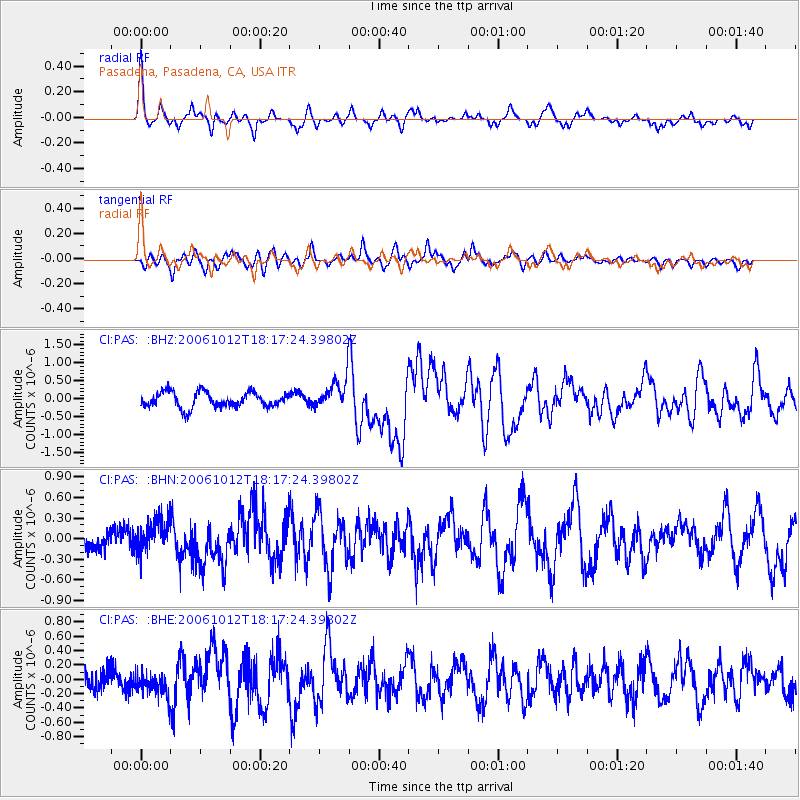
Signal To Noise
| Channel | StoN | STA | LTA |
| CI:PAS: :BHN:20061012T18:17:24.39802Z | 1.0044676 | 2.4303864E-7 | 2.4195768E-7 |
| CI:PAS: :BHE:20061012T18:17:24.39802Z | 0.7835032 | 1.6387031E-7 | 2.091508E-7 |
| CI:PAS: :BHZ:20061012T18:17:24.39802Z | 2.0777907 | 4.383204E-7 | 2.1095504E-7 |
| Arrivals |
| Ps | 3.2 SECOND |
| PpPs | 8.7 SECOND |
| PsPs/PpSs | 12 SECOND |


