You are here: Home > Network List > WY - Yellowstone Wyoming Seismic Network Stations List
> Station YHH Holmes Hill, YNP, WY, USA > Earthquake Result Viewer
YHH Holmes Hill, YNP, WY, USA - Earthquake Result Viewer
| Earthquake location: |
Tonga Islands |
| Earthquake latitude/longitude: |
-15.7/-173.3 |
| Earthquake time(UTC): |
2015/05/30 (150) 17:18:39 GMT |
| Earthquake Depth: |
51 km |
| Earthquake Magnitude: |
5.8 MB |
| Earthquake Catalog/Contributor: |
NEIC PDE/NEIC COMCAT |
|
| Network: |
WY Yellowstone Wyoming Seismic Network |
| Station: |
YHH Holmes Hill, YNP, WY, USA |
| Lat/Lon: |
44.79 N/110.85 W |
| Elevation: |
2717 m |
|
| Distance: |
82.7 deg |
| Az: |
39.544 deg |
| Baz: |
239.43 deg |
| Ray Param: |
0.04664196 |
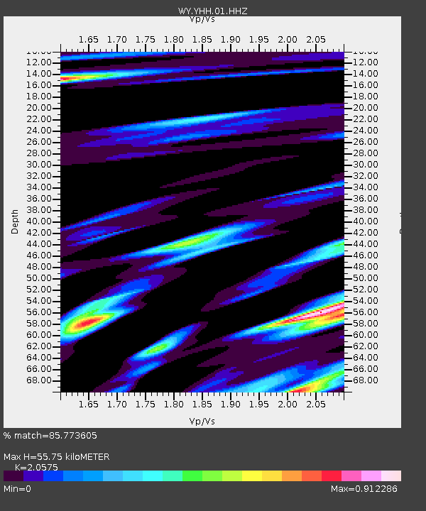
| Estimated Moho Depth: |
55.75 km |
| Estimated Crust Vp/Vs: |
2.06 |
| Assumed Crust Vp: |
6.35 km/s |
| Estimated Crust Vs: |
3.086 km/s |
| Estimated Crust Poisson's Ratio: |
0.35 |
|
| Radial Match: |
85.773605 % |
| Radial Bump: |
400 |
| Transverse Match: |
79.86515 % |
| Transverse Bump: |
400 |
| SOD ConfigId: |
976571 |
| Insert Time: |
2015-06-13 18:00:12.237 +0000 |
| GWidth: |
2.5 |
| Max Bumps: |
400 |
| Tol: |
0.001 |
|

Signal To Noise
| Channel | StoN | STA | LTA |
| WY:YHH:01:HHZ:20150530T17:30:26.507988Z | 12.623312 | 2.2941872E-8 | 1.817421E-9 |
| WY:YHH:01:HHN:20150530T17:30:26.507988Z | 2.3041627 | 4.62804E-9 | 2.008556E-9 |
| WY:YHH:01:HHE:20150530T17:30:26.507988Z | 5.1208434 | 9.022525E-9 | 1.7619216E-9 |
| Arrivals |
| Ps | 9.5 SECOND |
| PpPs | 26 SECOND |
| PsPs/PpSs | 36 SECOND |


