You are here: Home > Network List > CB - China National Seismic Network Stations List
> Station HEH Heihe,Heilongjiang Province > Earthquake Result Viewer
HEH Heihe,Heilongjiang Province - Earthquake Result Viewer
| Earthquake location: |
Timor Region |
| Earthquake latitude/longitude: |
-8.4/124.9 |
| Earthquake time(UTC): |
2015/11/04 (308) 03:44:15 GMT |
| Earthquake Depth: |
14 km |
| Earthquake Magnitude: |
6.3 MWP |
| Earthquake Catalog/Contributor: |
NEIC PDE/NEIC COMCAT |
|
| Network: |
CB China National Seismic Network |
| Station: |
HEH Heihe,Heilongjiang Province |
| Lat/Lon: |
50.25 N/127.41 E |
| Elevation: |
165 m |
|
| Distance: |
58.4 deg |
| Az: |
1.892 deg |
| Baz: |
182.917 deg |
| Ray Param: |
0.06285756 |
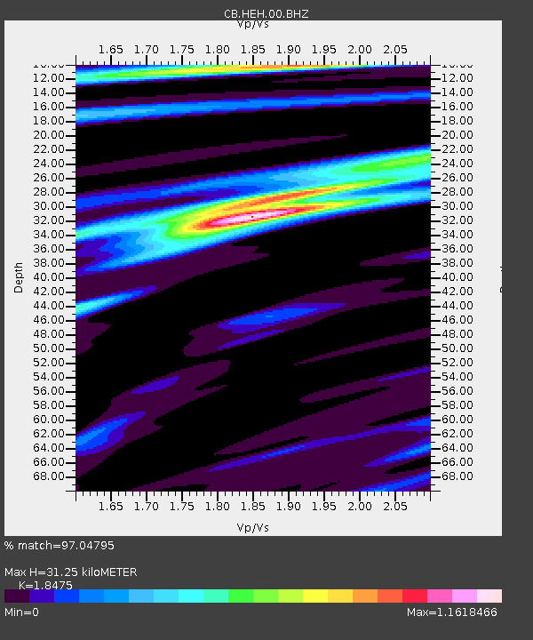
| Estimated Moho Depth: |
31.25 km |
| Estimated Crust Vp/Vs: |
1.85 |
| Assumed Crust Vp: |
6.419 km/s |
| Estimated Crust Vs: |
3.475 km/s |
| Estimated Crust Poisson's Ratio: |
0.29 |
|
| Radial Match: |
97.04795 % |
| Radial Bump: |
287 |
| Transverse Match: |
90.68591 % |
| Transverse Bump: |
350 |
| SOD ConfigId: |
7422571 |
| Insert Time: |
2019-04-21 06:00:20.350 +0000 |
| GWidth: |
2.5 |
| Max Bumps: |
400 |
| Tol: |
0.001 |
|
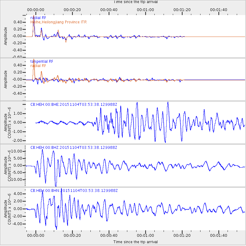
Signal To Noise
| Channel | StoN | STA | LTA |
| CB:HEH:00:BHZ:20151104T03:53:38.129988Z | 65.83788 | 5.2883333E-6 | 8.032357E-8 |
| CB:HEH:00:BHN:20151104T03:53:38.129988Z | 13.703103 | 2.1897388E-6 | 1.5979876E-7 |
| CB:HEH:00:BHE:20151104T03:53:38.129988Z | 5.7008953 | 5.3666867E-7 | 9.413762E-8 |
| Arrivals |
| Ps | 4.3 SECOND |
| PpPs | 13 SECOND |
| PsPs/PpSs | 18 SECOND |


