You are here: Home > Network List > CB - China National Seismic Network Stations List
> Station HHC Huhehaote,Neimeng Province > Earthquake Result Viewer
HHC Huhehaote,Neimeng Province - Earthquake Result Viewer
| Earthquake location: |
Timor Region |
| Earthquake latitude/longitude: |
-8.4/124.9 |
| Earthquake time(UTC): |
2015/11/04 (308) 03:44:15 GMT |
| Earthquake Depth: |
14 km |
| Earthquake Magnitude: |
6.3 MWP |
| Earthquake Catalog/Contributor: |
NEIC PDE/NEIC COMCAT |
|
| Network: |
CB China National Seismic Network |
| Station: |
HHC Huhehaote,Neimeng Province |
| Lat/Lon: |
40.85 N/111.56 E |
| Elevation: |
1169 m |
|
| Distance: |
50.5 deg |
| Az: |
346.89 deg |
| Baz: |
162.79 deg |
| Ray Param: |
0.06801961 |
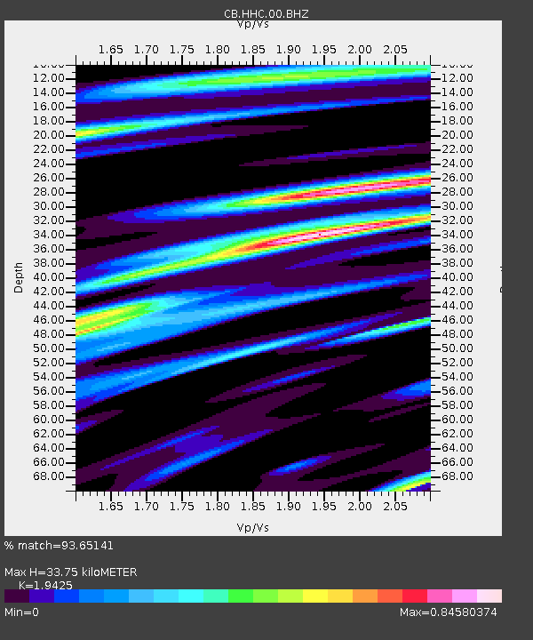
| Estimated Moho Depth: |
33.75 km |
| Estimated Crust Vp/Vs: |
1.94 |
| Assumed Crust Vp: |
6.384 km/s |
| Estimated Crust Vs: |
3.287 km/s |
| Estimated Crust Poisson's Ratio: |
0.32 |
|
| Radial Match: |
93.65141 % |
| Radial Bump: |
400 |
| Transverse Match: |
84.47209 % |
| Transverse Bump: |
400 |
| SOD ConfigId: |
7422571 |
| Insert Time: |
2019-04-21 06:00:20.611 +0000 |
| GWidth: |
2.5 |
| Max Bumps: |
400 |
| Tol: |
0.001 |
|

Signal To Noise
| Channel | StoN | STA | LTA |
| CB:HHC:00:BHZ:20151104T03:52:40.59001Z | 15.810076 | 2.0154512E-6 | 1.274789E-7 |
| CB:HHC:00:BHN:20151104T03:52:40.59001Z | 6.3140225 | 1.0137284E-6 | 1.605519E-7 |
| CB:HHC:00:BHE:20151104T03:52:40.59001Z | 2.118493 | 3.654632E-7 | 1.7251092E-7 |
| Arrivals |
| Ps | 5.2 SECOND |
| PpPs | 15 SECOND |
| PsPs/PpSs | 20 SECOND |


