You are here: Home > Network List > IC - New China Digital Seismograph Network Stations List
> Station BJT Baijiatuan, Beijing, China > Earthquake Result Viewer
BJT Baijiatuan, Beijing, China - Earthquake Result Viewer
| Earthquake location: |
Irian Jaya Region, Indonesia |
| Earthquake latitude/longitude: |
-0.9/136.1 |
| Earthquake time(UTC): |
1996/02/17 (048) 20:17:49 GMT |
| Earthquake Depth: |
33 km |
| Earthquake Magnitude: |
5.7 MB |
| Earthquake Catalog/Contributor: |
WHDF/NEIC |
|
| Network: |
IC New China Digital Seismograph Network |
| Station: |
BJT Baijiatuan, Beijing, China |
| Lat/Lon: |
40.02 N/116.17 E |
| Elevation: |
197 m |
|
| Distance: |
44.6 deg |
| Az: |
338.134 deg |
| Baz: |
150.994 deg |
| Ray Param: |
0.07172372 |
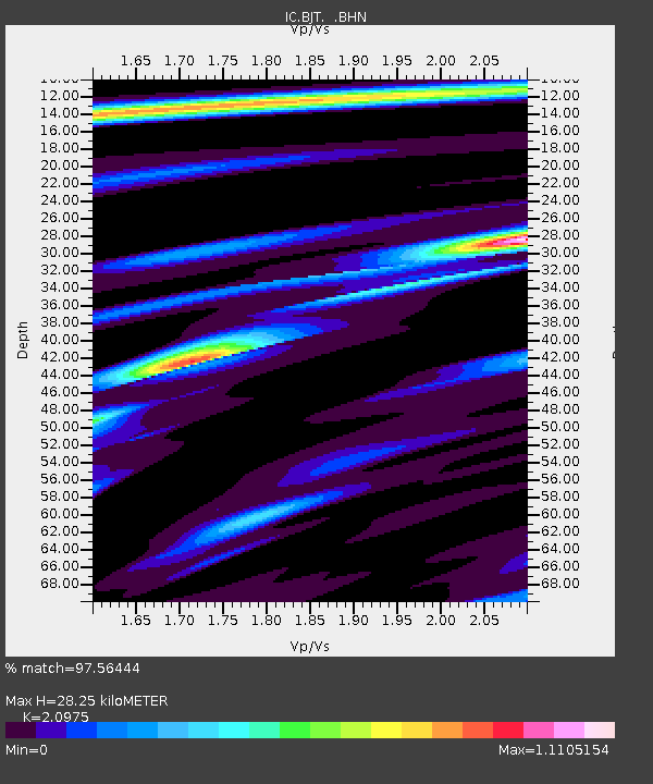
| Estimated Moho Depth: |
28.25 km |
| Estimated Crust Vp/Vs: |
2.10 |
| Assumed Crust Vp: |
6.464 km/s |
| Estimated Crust Vs: |
3.082 km/s |
| Estimated Crust Poisson's Ratio: |
0.35 |
|
| Radial Match: |
97.56444 % |
| Radial Bump: |
308 |
| Transverse Match: |
94.33472 % |
| Transverse Bump: |
400 |
| SOD ConfigId: |
4480 |
| Insert Time: |
2010-03-04 21:31:24.031 +0000 |
| GWidth: |
2.5 |
| Max Bumps: |
400 |
| Tol: |
0.001 |
|
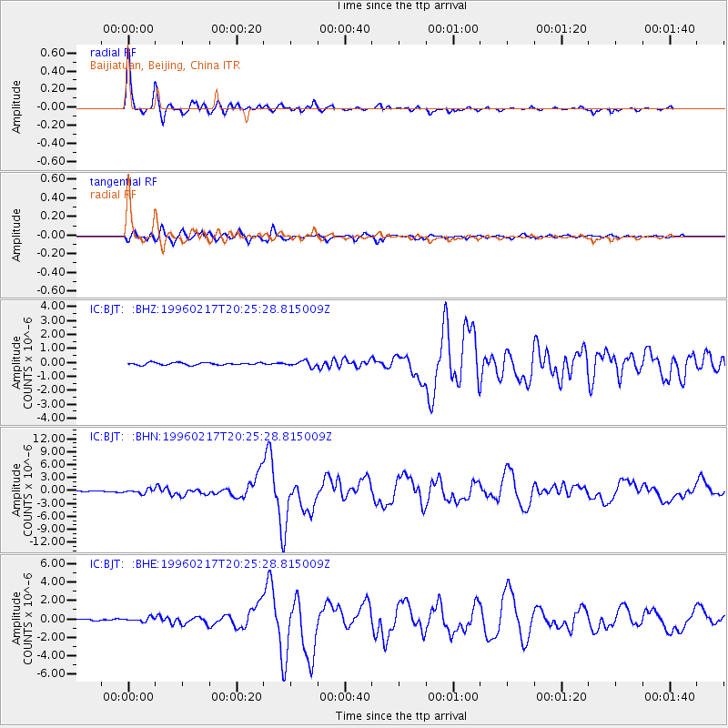
Signal To Noise
| Channel | StoN | STA | LTA |
| IC:BJT: :BHN:19960217T20:25:28.815009Z | 3.300745 | 4.8432634E-7 | 1.4673243E-7 |
| IC:BJT: :BHE:19960217T20:25:28.815009Z | 2.3179696 | 2.2469752E-7 | 9.6937214E-8 |
| IC:BJT: :BHZ:19960217T20:25:28.815009Z | 2.3369207 | 1.957099E-7 | 8.374691E-8 |
| Arrivals |
| Ps | 5.1 SECOND |
| PpPs | 13 SECOND |
| PsPs/PpSs | 18 SECOND |


