You are here: Home > Network List > ND - New CaleDonia Broadband Seismic Network Stations List
> Station KOUNC Koumac, New Caledonia > Earthquake Result Viewer
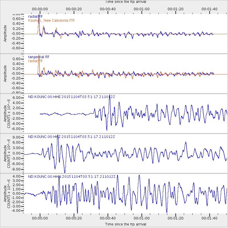
KOUNC Koumac, New Caledonia - Earthquake Result Viewer

| Earthquake location: |
Timor Region |
| Earthquake latitude/longitude: |
-8.4/124.9 |
| Earthquake time(UTC): |
2015/11/04 (308) 03:44:15 GMT |
| Earthquake Depth: |
14 km |
| Earthquake Magnitude: |
6.3 MWP |
| Earthquake Catalog/Contributor: |
NEIC PDE/NEIC COMCAT |
|
| Network: |
ND New CaleDonia Broadband Seismic Network |
| Station: |
KOUNC Koumac, New Caledonia |
| Lat/Lon: |
20.55 S/164.29 E |
| Elevation: |
88 m |
|
| Distance: |
39.9 deg |
| Az: |
112.044 deg |
| Baz: |
281.841 deg |
| Ray Param: |
0.074695356 |
| Estimated Moho Depth: |
60.5 km |
| Estimated Crust Vp/Vs: |
1.81 |
| Assumed Crust Vp: |
5.14 km/s |
| Estimated Crust Vs: |
2.844 km/s |
| Estimated Crust Poisson's Ratio: |
0.28 |
|
| Radial Match: |
86.14799 % |
| Radial Bump: |
400 |
| Transverse Match: |
67.79645 % |
| Transverse Bump: |
400 |
| SOD ConfigId: |
7422571 |
| Insert Time: |
2019-04-21 06:01:39.454 +0000 |
| GWidth: |
2.5 |
| Max Bumps: |
400 |
| Tol: |
0.001 |
|
Signal To Noise
| Channel | StoN | STA | LTA |
| ND:KOUNC:00:HHZ:20151104T03:51:17.211012Z | 3.9749932 | 1.4780285E-6 | 3.718317E-7 |
| ND:KOUNC:00:HHN:20151104T03:51:17.211012Z | 1.3918301 | 4.910761E-7 | 3.5282758E-7 |
| ND:KOUNC:00:HHE:20151104T03:51:17.211012Z | 4.7900133 | 1.04354E-6 | 2.1785743E-7 |
| Arrivals |
| Ps | 9.9 SECOND |
| PpPs | 32 SECOND |
| PsPs/PpSs | 42 SECOND |


