You are here: Home > Network List > PF - Volcanologic Network of Piton de Fournaise-OVPF Stations List
> Station BON Bory Nord > Earthquake Result Viewer
BON Bory Nord - Earthquake Result Viewer
| Earthquake location: |
Timor Region |
| Earthquake latitude/longitude: |
-8.4/124.9 |
| Earthquake time(UTC): |
2015/11/04 (308) 03:44:15 GMT |
| Earthquake Depth: |
14 km |
| Earthquake Magnitude: |
6.3 MWP |
| Earthquake Catalog/Contributor: |
NEIC PDE/NEIC COMCAT |
|
| Network: |
PF Volcanologic Network of Piton de Fournaise-OVPF |
| Station: |
BON Bory Nord |
| Lat/Lon: |
21.24 S/55.71 E |
| Elevation: |
2552 m |
|
| Distance: |
67.7 deg |
| Az: |
250.514 deg |
| Baz: |
90.497 deg |
| Ray Param: |
0.056796297 |
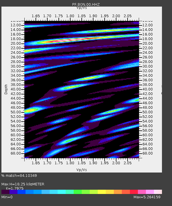
| Estimated Moho Depth: |
18.25 km |
| Estimated Crust Vp/Vs: |
1.80 |
| Assumed Crust Vp: |
4.73 km/s |
| Estimated Crust Vs: |
2.631 km/s |
| Estimated Crust Poisson's Ratio: |
0.28 |
|
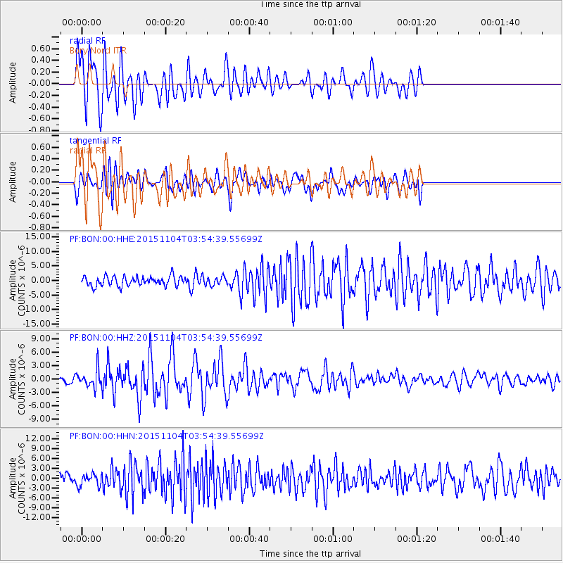
| Radial Match: |
84.10349 % |
| Radial Bump: |
400 |
| Transverse Match: |
69.54435 % |
| Transverse Bump: |
400 |
| SOD ConfigId: |
7422571 |
| Insert Time: |
2019-04-21 06:01:43.261 +0000 |
| GWidth: |
2.5 |
| Max Bumps: |
400 |
| Tol: |
0.001 |
|
Signal To Noise
| Channel | StoN | STA | LTA |
| PF:BON:00:HHZ:20151104T03:54:39.55699Z | 2.8231277 | 2.009286E-6 | 7.117234E-7 |
| PF:BON:00:HHN:20151104T03:54:39.55699Z | 0.80791265 | 1.8398863E-6 | 2.2773331E-6 |
| PF:BON:00:HHE:20151104T03:54:39.55699Z | 0.92922944 | 1.5126425E-6 | 1.6278461E-6 |
| Arrivals |
| Ps | 3.1 SECOND |
| PpPs | 11 SECOND |
| PsPs/PpSs | 14 SECOND |


