You are here: Home > Network List > XL12 - Hangay Dome, Mongolia Stations List
> Station HV17 HV17 > Earthquake Result Viewer
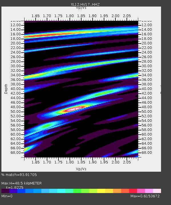
HV17 HV17 - Earthquake Result Viewer
| Earthquake location: |
Timor Region |
| Earthquake latitude/longitude: |
-8.4/124.9 |
| Earthquake time(UTC): |
2015/11/04 (308) 03:44:15 GMT |
| Earthquake Depth: |
14 km |
| Earthquake Magnitude: |
6.3 MWP |
| Earthquake Catalog/Contributor: |
NEIC PDE/NEIC COMCAT |
|
| Network: |
XL Hangay Dome, Mongolia |
| Station: |
HV17 HV17 |
| Lat/Lon: |
50.54 N/100.40 E |
| Elevation: |
1692 m |
|
| Distance: |
62.4 deg |
| Az: |
342.623 deg |
| Baz: |
152.412 deg |
| Ray Param: |
0.060250208 |
| Estimated Moho Depth: |
48.5 km |
| Estimated Crust Vp/Vs: |
1.82 |
| Assumed Crust Vp: |
6.419 km/s |
| Estimated Crust Vs: |
3.522 km/s |
| Estimated Crust Poisson's Ratio: |
0.28 |
|
| Radial Match: |
93.91705 % |
| Radial Bump: |
347 |
| Transverse Match: |
67.11732 % |
| Transverse Bump: |
400 |
| SOD ConfigId: |
7422571 |
| Insert Time: |
2019-04-21 06:02:45.087 +0000 |
| GWidth: |
2.5 |
| Max Bumps: |
400 |
| Tol: |
0.001 |
|

Signal To Noise
| Channel | StoN | STA | LTA |
| XL:HV17: :HHZ:20151104T03:54:05.270002Z | 45.624504 | 1.742818E-6 | 3.8199165E-8 |
| XL:HV17: :HHN:20151104T03:54:05.270002Z | 6.0273004 | 7.915622E-7 | 1.3132947E-7 |
| XL:HV17: :HHE:20151104T03:54:05.270002Z | 1.3837162 | 3.5653144E-7 | 2.5766226E-7 |
| Arrivals |
| Ps | 6.5 SECOND |
| PpPs | 20 SECOND |
| PsPs/PpSs | 27 SECOND |


