You are here: Home > Network List > YT07 - POLENET Stations List
> Station FISH FISH > Earthquake Result Viewer
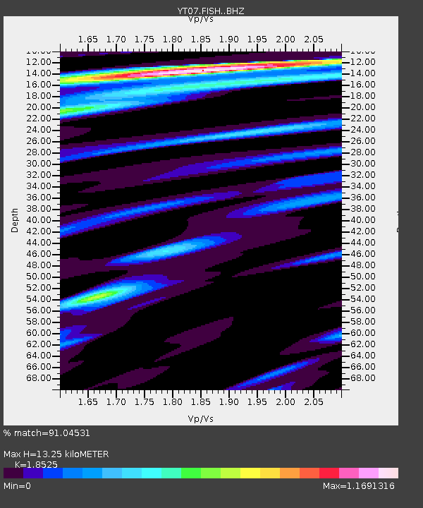
FISH FISH - Earthquake Result Viewer
| Earthquake location: |
Timor Region |
| Earthquake latitude/longitude: |
-8.4/124.9 |
| Earthquake time(UTC): |
2015/11/04 (308) 03:44:15 GMT |
| Earthquake Depth: |
14 km |
| Earthquake Magnitude: |
6.3 MWP |
| Earthquake Catalog/Contributor: |
NEIC PDE/NEIC COMCAT |
|
| Network: |
YT POLENET |
| Station: |
FISH FISH |
| Lat/Lon: |
78.93 S/162.57 E |
| Elevation: |
273 m |
|
| Distance: |
73.0 deg |
| Az: |
172.904 deg |
| Baz: |
320.771 deg |
| Ray Param: |
0.053308394 |
| Estimated Moho Depth: |
13.25 km |
| Estimated Crust Vp/Vs: |
1.85 |
| Assumed Crust Vp: |
6.43 km/s |
| Estimated Crust Vs: |
3.471 km/s |
| Estimated Crust Poisson's Ratio: |
0.29 |
|
| Radial Match: |
91.04531 % |
| Radial Bump: |
400 |
| Transverse Match: |
91.81513 % |
| Transverse Bump: |
400 |
| SOD ConfigId: |
7422571 |
| Insert Time: |
2019-04-21 06:03:20.900 +0000 |
| GWidth: |
2.5 |
| Max Bumps: |
400 |
| Tol: |
0.001 |
|

Signal To Noise
| Channel | StoN | STA | LTA |
| YT:FISH: :BHZ:20151104T03:55:12.049971Z | 6.115947 | 6.3368367E-7 | 1.03611704E-7 |
| YT:FISH: :BHN:20151104T03:55:12.049971Z | 2.044217 | 1.4248795E-7 | 6.970294E-8 |
| YT:FISH: :BHE:20151104T03:55:12.049971Z | 1.7654638 | 2.3398266E-7 | 1.3253326E-7 |
| Arrivals |
| Ps | 1.8 SECOND |
| PpPs | 5.7 SECOND |
| PsPs/PpSs | 7.5 SECOND |


