You are here: Home > Network List > UW - Pacific Northwest Regional Seismic Network Stations List
> Station UMAT Pilot Rock, OR, USA > Earthquake Result Viewer
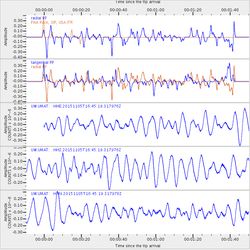
UMAT Pilot Rock, OR, USA - Earthquake Result Viewer
*The percent match for this event was below the threshold and hence no stack was calculated.
| Earthquake location: |
New Ireland Region, P.N.G. |
| Earthquake latitude/longitude: |
-3.7/150.9 |
| Earthquake time(UTC): |
2015/11/05 (309) 16:32:38 GMT |
| Earthquake Depth: |
10 km |
| Earthquake Magnitude: |
5.5 MWW, 5.4 MWB, 5.5 MWC |
| Earthquake Catalog/Contributor: |
NEIC PDE/NEIC COMCAT |
|
| Network: |
UW Pacific Northwest Regional Seismic Network |
| Station: |
UMAT Pilot Rock, OR, USA |
| Lat/Lon: |
45.29 N/118.96 W |
| Elevation: |
1318 m |
|
| Distance: |
92.7 deg |
| Az: |
44.967 deg |
| Baz: |
267.499 deg |
| Ray Param: |
$rayparam |
*The percent match for this event was below the threshold and hence was not used in the summary stack. |
|
| Radial Match: |
63.008076 % |
| Radial Bump: |
400 |
| Transverse Match: |
41.5614 % |
| Transverse Bump: |
400 |
| SOD ConfigId: |
7422571 |
| Insert Time: |
2019-04-21 06:13:35.587 +0000 |
| GWidth: |
2.5 |
| Max Bumps: |
400 |
| Tol: |
0.001 |
|
Signal To Noise
| Channel | StoN | STA | LTA |
| UW:UMAT: :HHZ:20151105T16:45:19.317976Z | 0.4743235 | 4.5128594E-8 | 9.514307E-8 |
| UW:UMAT: :HHN:20151105T16:45:19.317976Z | 1.8149209 | 1.7114117E-7 | 9.4296766E-8 |
| UW:UMAT: :HHE:20151105T16:45:19.317976Z | 1.0166662 | 8.274141E-8 | 8.138503E-8 |
| Arrivals |
| Ps | |
| PpPs | |
| PsPs/PpSs | |


