You are here: Home > Network List > GS - US Geological Survey Networks Stations List
> Station KAN11 Stewart Ranch, Harper County, KS, USA > Earthquake Result Viewer
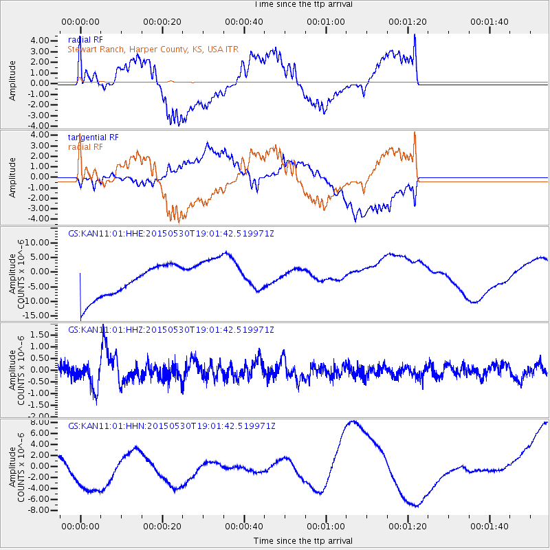
KAN11 Stewart Ranch, Harper County, KS, USA - Earthquake Result Viewer
*The percent match for this event was below the threshold and hence no stack was calculated.
| Earthquake location: |
Southeast Of Honshu, Japan |
| Earthquake latitude/longitude: |
30.8/143.0 |
| Earthquake time(UTC): |
2015/05/30 (150) 18:49:07 GMT |
| Earthquake Depth: |
13 km |
| Earthquake Magnitude: |
6.4 MO |
| Earthquake Catalog/Contributor: |
NEIC PDE/NEIC ALERT |
|
| Network: |
GS US Geological Survey Networks |
| Station: |
KAN11 Stewart Ranch, Harper County, KS, USA |
| Lat/Lon: |
37.21 N/97.91 W |
| Elevation: |
410 m |
|
| Distance: |
91.6 deg |
| Az: |
44.277 deg |
| Baz: |
311.181 deg |
| Ray Param: |
$rayparam |
*The percent match for this event was below the threshold and hence was not used in the summary stack. |
|
| Radial Match: |
29.694698 % |
| Radial Bump: |
375 |
| Transverse Match: |
39.613605 % |
| Transverse Bump: |
400 |
| SOD ConfigId: |
976571 |
| Insert Time: |
2015-06-13 19:19:49.806 +0000 |
| GWidth: |
2.5 |
| Max Bumps: |
400 |
| Tol: |
0.001 |
|
Signal To Noise
| Channel | StoN | STA | LTA |
| GS:KAN11:01:HHZ:20150530T19:01:42.519971Z | 2.3933477 | 5.45783E-7 | 2.2804164E-7 |
| GS:KAN11:01:HHN:20150530T19:01:42.519971Z | 5.0285473 | 7.2606467E-6 | 1.4438855E-6 |
| GS:KAN11:01:HHE:20150530T19:01:42.519971Z | 1.5359339 | 8.225824E-6 | 5.355585E-6 |
| Arrivals |
| Ps | |
| PpPs | |
| PsPs/PpSs | |


