You are here: Home > Network List > 7A - Mid-Atlantic Geophysical Integrative Collaboration Stations List
> Station INTX Elkton, Virginia USA > Earthquake Result Viewer
INTX Elkton, Virginia USA - Earthquake Result Viewer
| Earthquake location: |
Near Coast Of Central Chile |
| Earthquake latitude/longitude: |
-30.9/-71.5 |
| Earthquake time(UTC): |
2015/11/07 (311) 07:31:42 GMT |
| Earthquake Depth: |
36 km |
| Earthquake Magnitude: |
6.8 MWP, 6.8 MI |
| Earthquake Catalog/Contributor: |
NEIC PDE/NEIC COMCAT |
|
| Network: |
7A Mid-Atlantic Geophysical Integrative Collaboration |
| Station: |
INTX Elkton, Virginia USA |
| Lat/Lon: |
38.40 N/78.59 W |
| Elevation: |
320 m |
|
| Distance: |
69.3 deg |
| Az: |
354.089 deg |
| Baz: |
173.531 deg |
| Ray Param: |
0.055701442 |
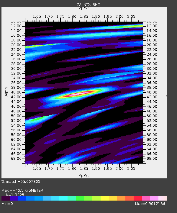
| Estimated Moho Depth: |
40.5 km |
| Estimated Crust Vp/Vs: |
1.82 |
| Assumed Crust Vp: |
6.159 km/s |
| Estimated Crust Vs: |
3.379 km/s |
| Estimated Crust Poisson's Ratio: |
0.28 |
|
| Radial Match: |
95.007805 % |
| Radial Bump: |
390 |
| Transverse Match: |
88.29203 % |
| Transverse Bump: |
400 |
| SOD ConfigId: |
7422571 |
| Insert Time: |
2019-04-21 06:22:46.525 +0000 |
| GWidth: |
2.5 |
| Max Bumps: |
400 |
| Tol: |
0.001 |
|

Signal To Noise
| Channel | StoN | STA | LTA |
| 7A:INTX: :BHZ:20151107T07:42:15.210017Z | 19.440714 | 6.19821E-6 | 3.1882627E-7 |
| 7A:INTX: :BHN:20151107T07:42:15.210017Z | 10.618248 | 3.3506865E-6 | 3.1555928E-7 |
| 7A:INTX: :BHE:20151107T07:42:15.210017Z | 2.3513367 | 6.217164E-7 | 2.6440978E-7 |
| Arrivals |
| Ps | 5.6 SECOND |
| PpPs | 18 SECOND |
| PsPs/PpSs | 24 SECOND |


