You are here: Home > Network List > IC - New China Digital Seismograph Network Stations List
> Station BJT Baijiatuan, Beijing, China > Earthquake Result Viewer
BJT Baijiatuan, Beijing, China - Earthquake Result Viewer
| Earthquake location: |
Philippine Islands Region |
| Earthquake latitude/longitude: |
7.7/127.6 |
| Earthquake time(UTC): |
1997/03/11 (070) 19:22:00 GMT |
| Earthquake Depth: |
10 km |
| Earthquake Magnitude: |
6.3 MB, 6.7 MS, 6.9 UNKNOWN, 6.8 MW |
| Earthquake Catalog/Contributor: |
WHDF/NEIC |
|
| Network: |
IC New China Digital Seismograph Network |
| Station: |
BJT Baijiatuan, Beijing, China |
| Lat/Lon: |
40.02 N/116.17 E |
| Elevation: |
197 m |
|
| Distance: |
33.7 deg |
| Az: |
344.029 deg |
| Baz: |
159.203 deg |
| Ray Param: |
0.07806749 |
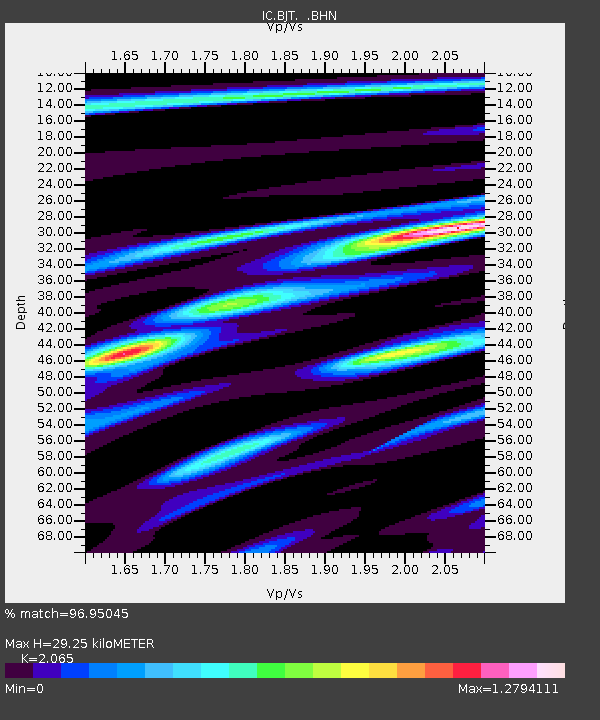
| Estimated Moho Depth: |
29.25 km |
| Estimated Crust Vp/Vs: |
2.07 |
| Assumed Crust Vp: |
6.464 km/s |
| Estimated Crust Vs: |
3.13 km/s |
| Estimated Crust Poisson's Ratio: |
0.35 |
|
| Radial Match: |
96.95045 % |
| Radial Bump: |
363 |
| Transverse Match: |
90.87728 % |
| Transverse Bump: |
400 |
| SOD ConfigId: |
4480 |
| Insert Time: |
2010-03-04 21:33:51.512 +0000 |
| GWidth: |
2.5 |
| Max Bumps: |
400 |
| Tol: |
0.001 |
|
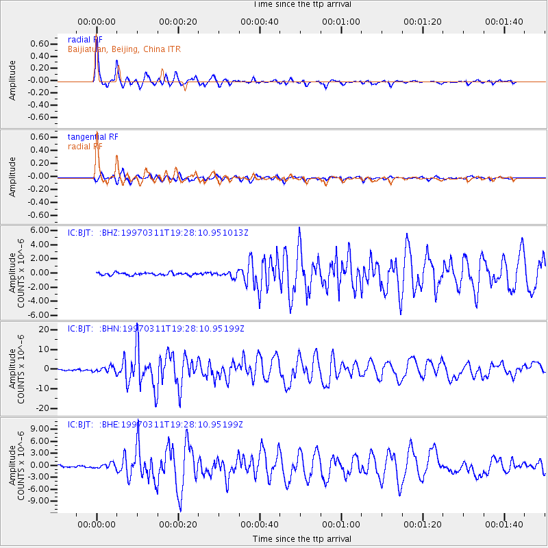
Signal To Noise
| Channel | StoN | STA | LTA |
| IC:BJT: :BHN:19970311T19:28:10.95199Z | 2.698939 | 1.4680267E-6 | 5.439273E-7 |
| IC:BJT: :BHE:19970311T19:28:10.95199Z | 2.870226 | 6.4334813E-7 | 2.2414547E-7 |
| IC:BJT: :BHZ:19970311T19:28:10.951013Z | 2.2059393 | 3.892465E-7 | 1.7645387E-7 |
| Arrivals |
| Ps | 5.2 SECOND |
| PpPs | 13 SECOND |
| PsPs/PpSs | 18 SECOND |


