You are here: Home > Network List > N4 - Central and EAstern US Network Stations List
> Station N38B Corydon, IA, USA > Earthquake Result Viewer
N38B Corydon, IA, USA - Earthquake Result Viewer
| Earthquake location: |
Near Coast Of Central Chile |
| Earthquake latitude/longitude: |
-30.9/-71.5 |
| Earthquake time(UTC): |
2015/11/07 (311) 07:31:42 GMT |
| Earthquake Depth: |
36 km |
| Earthquake Magnitude: |
6.8 MWP, 6.8 MI |
| Earthquake Catalog/Contributor: |
NEIC PDE/NEIC COMCAT |
|
| Network: |
N4 Central and EAstern US Network |
| Station: |
N38B Corydon, IA, USA |
| Lat/Lon: |
40.79 N/93.24 W |
| Elevation: |
322 m |
|
| Distance: |
74.1 deg |
| Az: |
343.037 deg |
| Baz: |
160.713 deg |
| Ray Param: |
0.052495778 |
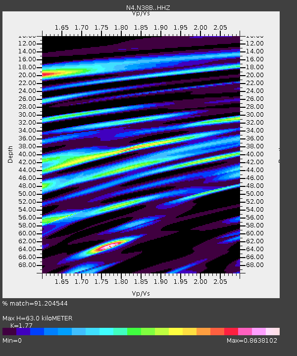
| Estimated Moho Depth: |
63.0 km |
| Estimated Crust Vp/Vs: |
1.77 |
| Assumed Crust Vp: |
6.498 km/s |
| Estimated Crust Vs: |
3.671 km/s |
| Estimated Crust Poisson's Ratio: |
0.27 |
|
| Radial Match: |
91.204544 % |
| Radial Bump: |
400 |
| Transverse Match: |
80.55027 % |
| Transverse Bump: |
400 |
| SOD ConfigId: |
7422571 |
| Insert Time: |
2019-04-21 06:28:31.231 +0000 |
| GWidth: |
2.5 |
| Max Bumps: |
400 |
| Tol: |
0.001 |
|

Signal To Noise
| Channel | StoN | STA | LTA |
| N4:N38B: :HHZ:20151107T07:42:44.340022Z | 26.934774 | 7.5793846E-6 | 2.8139772E-7 |
| N4:N38B: :HHN:20151107T07:42:44.340022Z | 8.043388 | 3.214993E-6 | 3.997063E-7 |
| N4:N38B: :HHE:20151107T07:42:44.340022Z | 3.6182008 | 1.2232478E-6 | 3.3808178E-7 |
| Arrivals |
| Ps | 7.7 SECOND |
| PpPs | 26 SECOND |
| PsPs/PpSs | 34 SECOND |


