You are here: Home > Network List > NN - Western Great Basin/Eastern Sierra Nevada Stations List
> Station LCH Last Chance Range, CA. (GPS 01/04/2001) w84 > Earthquake Result Viewer
LCH Last Chance Range, CA. (GPS 01/04/2001) w84 - Earthquake Result Viewer
| Earthquake location: |
Near Coast Of Central Chile |
| Earthquake latitude/longitude: |
-30.9/-71.5 |
| Earthquake time(UTC): |
2015/11/07 (311) 07:31:42 GMT |
| Earthquake Depth: |
36 km |
| Earthquake Magnitude: |
6.8 MWP, 6.8 MI |
| Earthquake Catalog/Contributor: |
NEIC PDE/NEIC COMCAT |
|
| Network: |
NN Western Great Basin/Eastern Sierra Nevada |
| Station: |
LCH Last Chance Range, CA. (GPS 01/04/2001) w84 |
| Lat/Lon: |
37.23 N/117.65 W |
| Elevation: |
1414 m |
|
| Distance: |
80.3 deg |
| Az: |
324.311 deg |
| Baz: |
141.079 deg |
| Ray Param: |
0.048288763 |
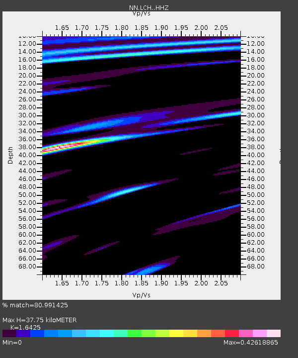
| Estimated Moho Depth: |
37.75 km |
| Estimated Crust Vp/Vs: |
1.64 |
| Assumed Crust Vp: |
6.279 km/s |
| Estimated Crust Vs: |
3.823 km/s |
| Estimated Crust Poisson's Ratio: |
0.21 |
|
| Radial Match: |
80.991425 % |
| Radial Bump: |
400 |
| Transverse Match: |
82.33244 % |
| Transverse Bump: |
400 |
| SOD ConfigId: |
7422571 |
| Insert Time: |
2019-04-21 06:29:49.791 +0000 |
| GWidth: |
2.5 |
| Max Bumps: |
400 |
| Tol: |
0.001 |
|

Signal To Noise
| Channel | StoN | STA | LTA |
| NN:LCH: :HHZ:20151107T07:43:19.27801Z | 15.876152 | 3.6307404E-6 | 2.2869146E-7 |
| NN:LCH: :HHN:20151107T07:43:19.27801Z | 2.4566705 | 7.591822E-7 | 3.0902893E-7 |
| NN:LCH: :HHE:20151107T07:43:19.27801Z | 4.2779264 | 1.0724436E-6 | 2.5069238E-7 |
| Arrivals |
| Ps | 4.0 SECOND |
| PpPs | 15 SECOND |
| PsPs/PpSs | 19 SECOND |


