You are here: Home > Network List > TA - USArray Transportable Network (new EarthScope stations) Stations List
> Station 435B Jarrell, TX, USA > Earthquake Result Viewer
435B Jarrell, TX, USA - Earthquake Result Viewer
| Earthquake location: |
Near Coast Of Central Chile |
| Earthquake latitude/longitude: |
-30.9/-71.5 |
| Earthquake time(UTC): |
2015/11/07 (311) 07:31:42 GMT |
| Earthquake Depth: |
36 km |
| Earthquake Magnitude: |
6.8 MWP, 6.8 MI |
| Earthquake Catalog/Contributor: |
NEIC PDE/NEIC COMCAT |
|
| Network: |
TA USArray Transportable Network (new EarthScope stations) |
| Station: |
435B Jarrell, TX, USA |
| Lat/Lon: |
30.78 N/97.58 W |
| Elevation: |
248 m |
|
| Distance: |
66.1 deg |
| Az: |
335.6 deg |
| Baz: |
155.633 deg |
| Ray Param: |
0.05774386 |
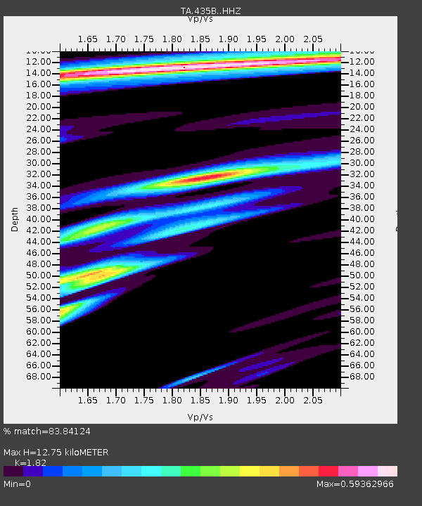
| Estimated Moho Depth: |
12.75 km |
| Estimated Crust Vp/Vs: |
1.82 |
| Assumed Crust Vp: |
6.347 km/s |
| Estimated Crust Vs: |
3.487 km/s |
| Estimated Crust Poisson's Ratio: |
0.28 |
|
| Radial Match: |
83.84124 % |
| Radial Bump: |
400 |
| Transverse Match: |
78.75873 % |
| Transverse Bump: |
400 |
| SOD ConfigId: |
7422571 |
| Insert Time: |
2019-04-21 06:32:16.342 +0000 |
| GWidth: |
2.5 |
| Max Bumps: |
400 |
| Tol: |
0.001 |
|

Signal To Noise
| Channel | StoN | STA | LTA |
| TA:435B: :HHZ:20151107T07:41:55.799983Z | 20.894386 | 4.571653E-6 | 2.1879815E-7 |
| TA:435B: :HHN:20151107T07:41:55.799983Z | 5.3723693 | 1.4167831E-6 | 2.6371666E-7 |
| TA:435B: :HHE:20151107T07:41:55.799983Z | 2.759313 | 6.8644664E-7 | 2.4877446E-7 |
| Arrivals |
| Ps | 1.7 SECOND |
| PpPs | 5.5 SECOND |
| PsPs/PpSs | 7.2 SECOND |


