You are here: Home > Network List > TA - USArray Transportable Network (new EarthScope stations) Stations List
> Station J05D Fort Rock, OR, USA > Earthquake Result Viewer
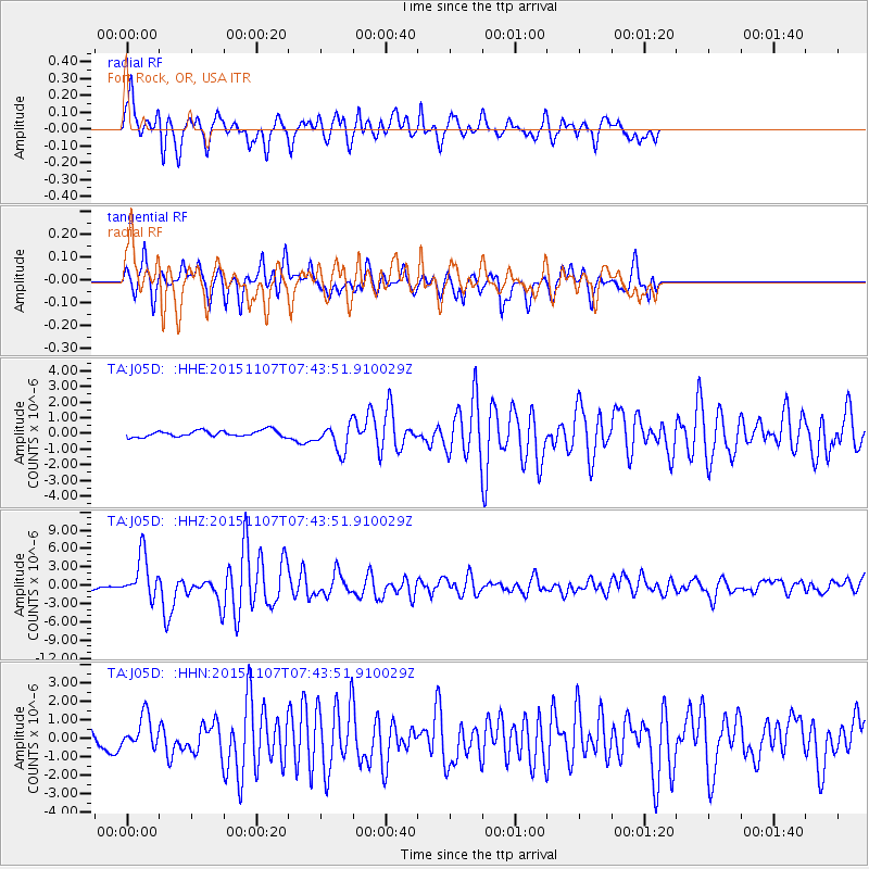
J05D Fort Rock, OR, USA - Earthquake Result Viewer
| Earthquake location: |
Near Coast Of Central Chile |
| Earthquake latitude/longitude: |
-30.9/-71.5 |
| Earthquake time(UTC): |
2015/11/07 (311) 07:31:42 GMT |
| Earthquake Depth: |
36 km |
| Earthquake Magnitude: |
6.8 MWP, 6.8 MI |
| Earthquake Catalog/Contributor: |
NEIC PDE/NEIC COMCAT |
|
| Network: |
TA USArray Transportable Network (new EarthScope stations) |
| Station: |
J05D Fort Rock, OR, USA |
| Lat/Lon: |
43.28 N/121.23 W |
| Elevation: |
1541 m |
|
| Distance: |
86.7 deg |
| Az: |
326.099 deg |
| Baz: |
138.966 deg |
| Ray Param: |
0.043781765 |
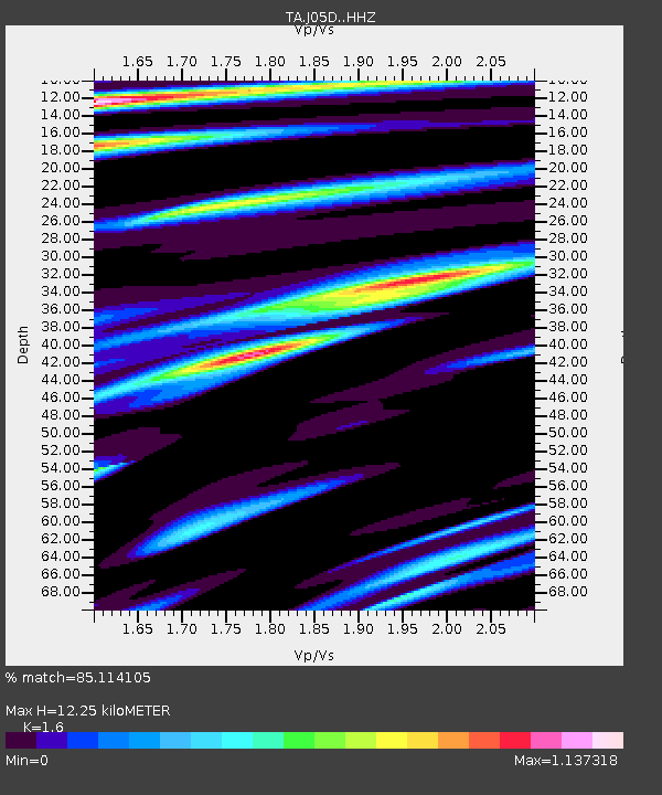
| Estimated Moho Depth: |
12.25 km |
| Estimated Crust Vp/Vs: |
1.60 |
| Assumed Crust Vp: |
6.597 km/s |
| Estimated Crust Vs: |
4.123 km/s |
| Estimated Crust Poisson's Ratio: |
0.18 |
|
| Radial Match: |
85.114105 % |
| Radial Bump: |
400 |
| Transverse Match: |
75.36392 % |
| Transverse Bump: |
341 |
| SOD ConfigId: |
7422571 |
| Insert Time: |
2019-04-21 06:32:36.528 +0000 |
| GWidth: |
2.5 |
| Max Bumps: |
400 |
| Tol: |
0.001 |
|
Signal To Noise
| Channel | StoN | STA | LTA |
| TA:J05D: :HHZ:20151107T07:43:51.910029Z | 8.6780205 | 3.4786972E-6 | 4.0086297E-7 |
| TA:J05D: :HHN:20151107T07:43:51.910029Z | 1.7227632 | 8.6591524E-7 | 5.026316E-7 |
| TA:J05D: :HHE:20151107T07:43:51.910029Z | 4.3822684 | 8.650616E-7 | 1.9740041E-7 |
| Arrivals |
| Ps | 1.1 SECOND |
| PpPs | 4.7 SECOND |
| PsPs/PpSs | 5.8 SECOND |


