You are here: Home > Network List > TA - USArray Transportable Network (new EarthScope stations) Stations List
> Station N54A Moraine State Park, Portersville, PA, USA > Earthquake Result Viewer
N54A Moraine State Park, Portersville, PA, USA - Earthquake Result Viewer
| Earthquake location: |
Near Coast Of Central Chile |
| Earthquake latitude/longitude: |
-30.9/-71.5 |
| Earthquake time(UTC): |
2015/11/07 (311) 07:31:42 GMT |
| Earthquake Depth: |
36 km |
| Earthquake Magnitude: |
6.8 MWP, 6.8 MI |
| Earthquake Catalog/Contributor: |
NEIC PDE/NEIC COMCAT |
|
| Network: |
TA USArray Transportable Network (new EarthScope stations) |
| Station: |
N54A Moraine State Park, Portersville, PA, USA |
| Lat/Lon: |
40.96 N/79.99 W |
| Elevation: |
408 m |
|
| Distance: |
71.9 deg |
| Az: |
353.282 deg |
| Baz: |
172.37 deg |
| Ray Param: |
0.053938817 |
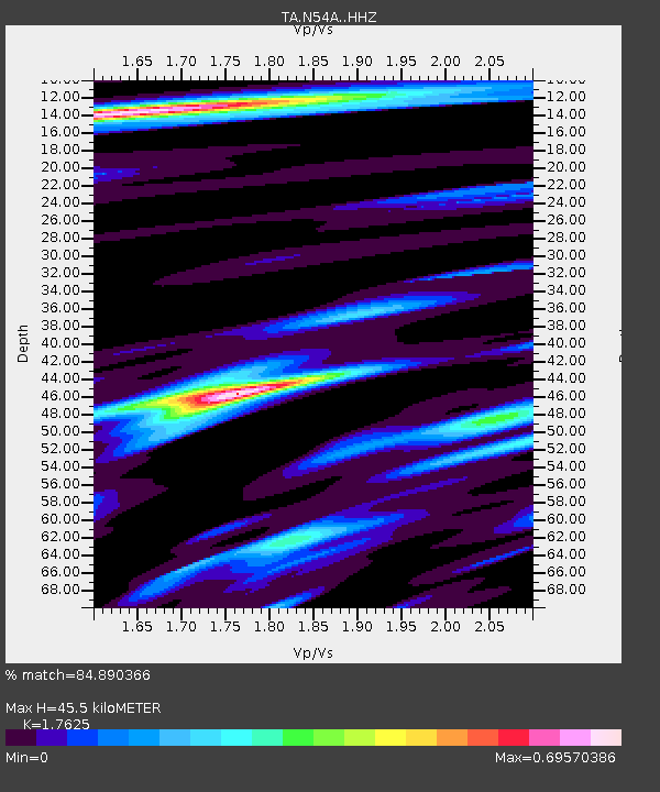
| Estimated Moho Depth: |
45.5 km |
| Estimated Crust Vp/Vs: |
1.76 |
| Assumed Crust Vp: |
6.121 km/s |
| Estimated Crust Vs: |
3.473 km/s |
| Estimated Crust Poisson's Ratio: |
0.26 |
|
| Radial Match: |
84.890366 % |
| Radial Bump: |
309 |
| Transverse Match: |
72.53993 % |
| Transverse Bump: |
369 |
| SOD ConfigId: |
7422571 |
| Insert Time: |
2019-04-21 06:32:51.721 +0000 |
| GWidth: |
2.5 |
| Max Bumps: |
400 |
| Tol: |
0.001 |
|

Signal To Noise
| Channel | StoN | STA | LTA |
| TA:N54A: :HHZ:20151107T07:42:31.410029Z | 10.281294 | 6.8020763E-6 | 6.615973E-7 |
| TA:N54A: :HHN:20151107T07:42:31.410029Z | 4.7067375 | 2.3195994E-6 | 4.9282534E-7 |
| TA:N54A: :HHE:20151107T07:42:31.410029Z | 0.96534747 | 4.4053954E-7 | 4.5635332E-7 |
| Arrivals |
| Ps | 5.9 SECOND |
| PpPs | 20 SECOND |
| PsPs/PpSs | 26 SECOND |


