You are here: Home > Network List > TA - USArray Transportable Network (new EarthScope stations) Stations List
> Station N59A State Game Land 141, Hazleton, PA, USA > Earthquake Result Viewer
N59A State Game Land 141, Hazleton, PA, USA - Earthquake Result Viewer
| Earthquake location: |
Near Coast Of Central Chile |
| Earthquake latitude/longitude: |
-30.9/-71.5 |
| Earthquake time(UTC): |
2015/11/07 (311) 07:31:42 GMT |
| Earthquake Depth: |
36 km |
| Earthquake Magnitude: |
6.8 MWP, 6.8 MI |
| Earthquake Catalog/Contributor: |
NEIC PDE/NEIC COMCAT |
|
| Network: |
TA USArray Transportable Network (new EarthScope stations) |
| Station: |
N59A State Game Land 141, Hazleton, PA, USA |
| Lat/Lon: |
40.92 N/75.77 W |
| Elevation: |
508 m |
|
| Distance: |
71.6 deg |
| Az: |
356.625 deg |
| Baz: |
176.172 deg |
| Ray Param: |
0.05418167 |
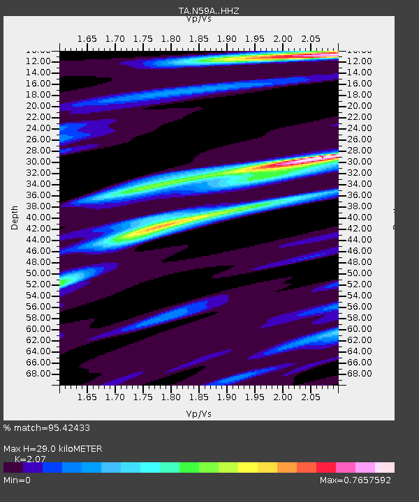
| Estimated Moho Depth: |
29.0 km |
| Estimated Crust Vp/Vs: |
2.07 |
| Assumed Crust Vp: |
6.283 km/s |
| Estimated Crust Vs: |
3.035 km/s |
| Estimated Crust Poisson's Ratio: |
0.35 |
|
| Radial Match: |
95.42433 % |
| Radial Bump: |
236 |
| Transverse Match: |
86.70692 % |
| Transverse Bump: |
362 |
| SOD ConfigId: |
7422571 |
| Insert Time: |
2019-04-21 06:32:52.034 +0000 |
| GWidth: |
2.5 |
| Max Bumps: |
400 |
| Tol: |
0.001 |
|
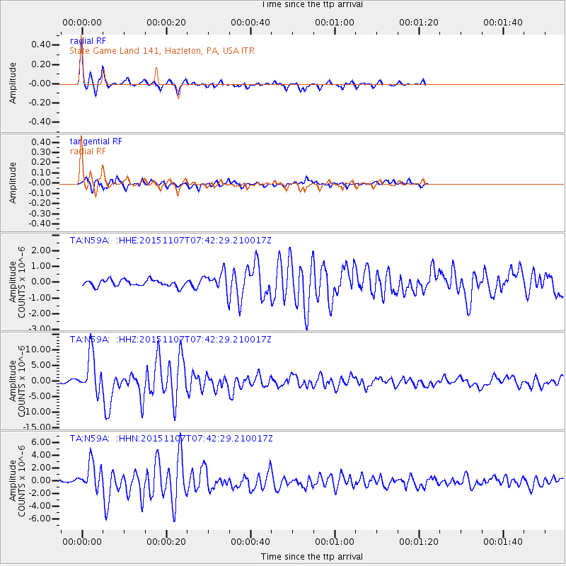
Signal To Noise
| Channel | StoN | STA | LTA |
| TA:N59A: :HHZ:20151107T07:42:29.210017Z | 15.0681305 | 6.3460575E-6 | 4.2115758E-7 |
| TA:N59A: :HHN:20151107T07:42:29.210017Z | 8.696167 | 2.165869E-6 | 2.4906018E-7 |
| TA:N59A: :HHE:20151107T07:42:29.210017Z | 3.4087 | 6.970301E-7 | 2.0448562E-7 |
| Arrivals |
| Ps | 5.1 SECOND |
| PpPs | 14 SECOND |
| PsPs/PpSs | 19 SECOND |


