You are here: Home > Network List > TA - USArray Transportable Network (new EarthScope stations) Stations List
> Station Q24A Divide, CO, USA > Earthquake Result Viewer
Q24A Divide, CO, USA - Earthquake Result Viewer
| Earthquake location: |
Near Coast Of Central Chile |
| Earthquake latitude/longitude: |
-30.9/-71.5 |
| Earthquake time(UTC): |
2015/11/07 (311) 07:31:42 GMT |
| Earthquake Depth: |
36 km |
| Earthquake Magnitude: |
6.8 MWP, 6.8 MI |
| Earthquake Catalog/Contributor: |
NEIC PDE/NEIC COMCAT |
|
| Network: |
TA USArray Transportable Network (new EarthScope stations) |
| Station: |
Q24A Divide, CO, USA |
| Lat/Lon: |
38.96 N/105.15 W |
| Elevation: |
2775 m |
|
| Distance: |
76.2 deg |
| Az: |
333.625 deg |
| Baz: |
150.673 deg |
| Ray Param: |
0.051078483 |
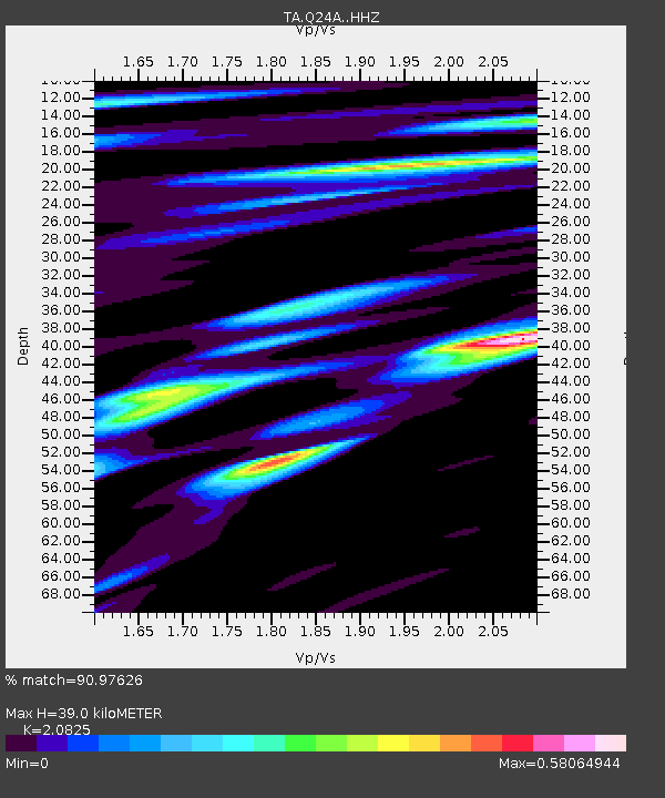
| Estimated Moho Depth: |
39.0 km |
| Estimated Crust Vp/Vs: |
2.08 |
| Assumed Crust Vp: |
6.159 km/s |
| Estimated Crust Vs: |
2.957 km/s |
| Estimated Crust Poisson's Ratio: |
0.35 |
|
| Radial Match: |
90.97626 % |
| Radial Bump: |
364 |
| Transverse Match: |
86.8449 % |
| Transverse Bump: |
393 |
| SOD ConfigId: |
7422571 |
| Insert Time: |
2019-04-21 06:32:58.966 +0000 |
| GWidth: |
2.5 |
| Max Bumps: |
400 |
| Tol: |
0.001 |
|
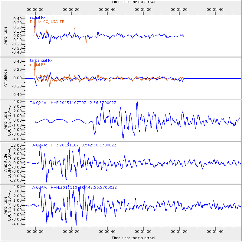
Signal To Noise
| Channel | StoN | STA | LTA |
| TA:Q24A: :HHZ:20151107T07:42:56.570002Z | 14.253462 | 4.6733307E-6 | 3.2787338E-7 |
| TA:Q24A: :HHN:20151107T07:42:56.570002Z | 5.0463414 | 1.4697845E-6 | 2.9125744E-7 |
| TA:Q24A: :HHE:20151107T07:42:56.570002Z | 5.069512 | 1.2622089E-6 | 2.4898037E-7 |
| Arrivals |
| Ps | 7.0 SECOND |
| PpPs | 19 SECOND |
| PsPs/PpSs | 26 SECOND |


