You are here: Home > Network List > TA - USArray Transportable Network (new EarthScope stations) Stations List
> Station P60A Greenville, DE, USA > Earthquake Result Viewer
P60A Greenville, DE, USA - Earthquake Result Viewer
| Earthquake location: |
Near Coast Of Central Chile |
| Earthquake latitude/longitude: |
-30.9/-71.5 |
| Earthquake time(UTC): |
2015/11/07 (311) 07:31:42 GMT |
| Earthquake Depth: |
36 km |
| Earthquake Magnitude: |
6.8 MWP, 6.8 MI |
| Earthquake Catalog/Contributor: |
NEIC PDE/NEIC COMCAT |
|
| Network: |
TA USArray Transportable Network (new EarthScope stations) |
| Station: |
P60A Greenville, DE, USA |
| Lat/Lon: |
39.81 N/75.64 W |
| Elevation: |
105 m |
|
| Distance: |
70.5 deg |
| Az: |
356.657 deg |
| Baz: |
176.269 deg |
| Ray Param: |
0.0549087 |
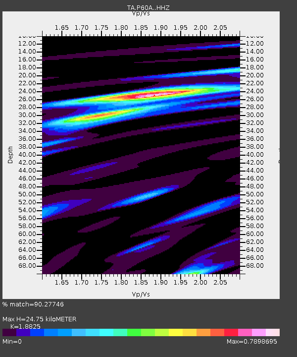
| Estimated Moho Depth: |
24.75 km |
| Estimated Crust Vp/Vs: |
1.88 |
| Assumed Crust Vp: |
6.287 km/s |
| Estimated Crust Vs: |
3.34 km/s |
| Estimated Crust Poisson's Ratio: |
0.30 |
|
| Radial Match: |
90.27746 % |
| Radial Bump: |
317 |
| Transverse Match: |
77.06885 % |
| Transverse Bump: |
400 |
| SOD ConfigId: |
7422571 |
| Insert Time: |
2019-04-21 06:32:59.778 +0000 |
| GWidth: |
2.5 |
| Max Bumps: |
400 |
| Tol: |
0.001 |
|

Signal To Noise
| Channel | StoN | STA | LTA |
| TA:P60A: :HHZ:20151107T07:42:22.510005Z | 12.038368 | 5.3757612E-6 | 4.4655232E-7 |
| TA:P60A: :HHN:20151107T07:42:22.510005Z | 7.309911 | 2.3102864E-6 | 3.1604853E-7 |
| TA:P60A: :HHE:20151107T07:42:22.510005Z | 1.6988583 | 5.3411026E-7 | 3.1439367E-7 |
| Arrivals |
| Ps | 3.6 SECOND |
| PpPs | 11 SECOND |
| PsPs/PpSs | 15 SECOND |


