You are here: Home > Network List > TA - USArray Transportable Network (new EarthScope stations) Stations List
> Station Q61A Milford, DE, USA > Earthquake Result Viewer
Q61A Milford, DE, USA - Earthquake Result Viewer
| Earthquake location: |
Near Coast Of Central Chile |
| Earthquake latitude/longitude: |
-30.9/-71.5 |
| Earthquake time(UTC): |
2015/11/07 (311) 07:31:42 GMT |
| Earthquake Depth: |
36 km |
| Earthquake Magnitude: |
6.8 MWP, 6.8 MI |
| Earthquake Catalog/Contributor: |
NEIC PDE/NEIC COMCAT |
|
| Network: |
TA USArray Transportable Network (new EarthScope stations) |
| Station: |
Q61A Milford, DE, USA |
| Lat/Lon: |
38.88 N/75.33 W |
| Elevation: |
5.0 m |
|
| Distance: |
69.5 deg |
| Az: |
356.85 deg |
| Baz: |
176.531 deg |
| Ray Param: |
0.055534754 |
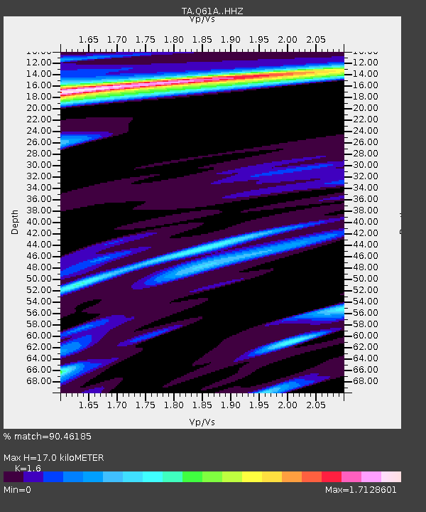
| Estimated Moho Depth: |
17.0 km |
| Estimated Crust Vp/Vs: |
1.60 |
| Assumed Crust Vp: |
6.287 km/s |
| Estimated Crust Vs: |
3.93 km/s |
| Estimated Crust Poisson's Ratio: |
0.18 |
|
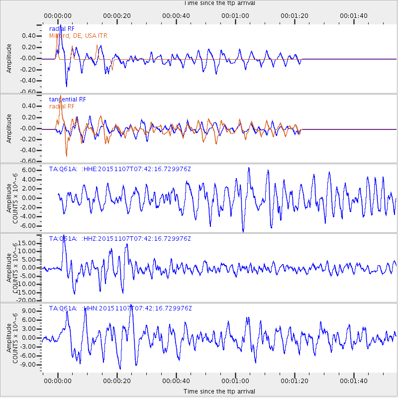
| Radial Match: |
90.46185 % |
| Radial Bump: |
400 |
| Transverse Match: |
66.37967 % |
| Transverse Bump: |
393 |
| SOD ConfigId: |
7422571 |
| Insert Time: |
2019-04-21 06:33:00.932 +0000 |
| GWidth: |
2.5 |
| Max Bumps: |
400 |
| Tol: |
0.001 |
|
Signal To Noise
| Channel | StoN | STA | LTA |
| TA:Q61A: :HHZ:20151107T07:42:16.729976Z | 10.638954 | 7.5718945E-6 | 7.1171416E-7 |
| TA:Q61A: :HHN:20151107T07:42:16.729976Z | 5.137709 | 3.9715933E-6 | 7.730281E-7 |
| TA:Q61A: :HHE:20151107T07:42:16.729976Z | 0.89409375 | 1.3964672E-6 | 1.5618799E-6 |
| Arrivals |
| Ps | 1.7 SECOND |
| PpPs | 6.8 SECOND |
| PsPs/PpSs | 8.4 SECOND |


