You are here: Home > Network List > TA - USArray Transportable Network (new EarthScope stations) Stations List
> Station T25A Trinidad, CO, USA > Earthquake Result Viewer
T25A Trinidad, CO, USA - Earthquake Result Viewer

| Earthquake location: |
Near Coast Of Central Chile |
| Earthquake latitude/longitude: |
-30.9/-71.5 |
| Earthquake time(UTC): |
2015/11/07 (311) 07:31:42 GMT |
| Earthquake Depth: |
36 km |
| Earthquake Magnitude: |
6.8 MWP, 6.8 MI |
| Earthquake Catalog/Contributor: |
NEIC PDE/NEIC COMCAT |
|
| Network: |
TA USArray Transportable Network (new EarthScope stations) |
| Station: |
T25A Trinidad, CO, USA |
| Lat/Lon: |
37.14 N/104.41 W |
| Elevation: |
2017 m |
|
| Distance: |
74.4 deg |
| Az: |
333.233 deg |
| Baz: |
151.027 deg |
| Ray Param: |
0.05233256 |
| Estimated Moho Depth: |
39.75 km |
| Estimated Crust Vp/Vs: |
1.90 |
| Assumed Crust Vp: |
6.316 km/s |
| Estimated Crust Vs: |
3.328 km/s |
| Estimated Crust Poisson's Ratio: |
0.31 |
|
| Radial Match: |
91.069534 % |
| Radial Bump: |
369 |
| Transverse Match: |
80.03385 % |
| Transverse Bump: |
387 |
| SOD ConfigId: |
7422571 |
| Insert Time: |
2019-04-21 06:33:05.806 +0000 |
| GWidth: |
2.5 |
| Max Bumps: |
400 |
| Tol: |
0.001 |
|
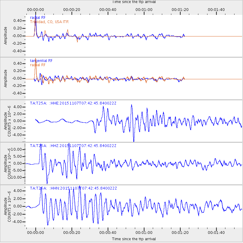
Signal To Noise
| Channel | StoN | STA | LTA |
| TA:T25A: :HHZ:20151107T07:42:45.840022Z | 14.403774 | 5.280103E-6 | 3.6657775E-7 |
| TA:T25A: :HHN:20151107T07:42:45.840022Z | 7.6350493 | 1.9360125E-6 | 2.5356908E-7 |
| TA:T25A: :HHE:20151107T07:42:45.840022Z | 4.4438133 | 1.2356617E-6 | 2.7806334E-7 |
| Arrivals |
| Ps | 5.8 SECOND |
| PpPs | 18 SECOND |
| PsPs/PpSs | 24 SECOND |


