You are here: Home > Network List > TA - USArray Transportable Network (new EarthScope stations) Stations List
> Station Z41A Richland Creek Farm, El Dorado, AR, USA > Earthquake Result Viewer
Z41A Richland Creek Farm, El Dorado, AR, USA - Earthquake Result Viewer
| Earthquake location: |
Near Coast Of Central Chile |
| Earthquake latitude/longitude: |
-30.9/-71.5 |
| Earthquake time(UTC): |
2015/11/07 (311) 07:31:42 GMT |
| Earthquake Depth: |
36 km |
| Earthquake Magnitude: |
6.8 MWP, 6.8 MI |
| Earthquake Catalog/Contributor: |
NEIC PDE/NEIC COMCAT |
|
| Network: |
TA USArray Transportable Network (new EarthScope stations) |
| Station: |
Z41A Richland Creek Farm, El Dorado, AR, USA |
| Lat/Lon: |
33.26 N/92.80 W |
| Elevation: |
62 m |
|
| Distance: |
66.9 deg |
| Az: |
340.715 deg |
| Baz: |
160.197 deg |
| Ray Param: |
0.057242103 |
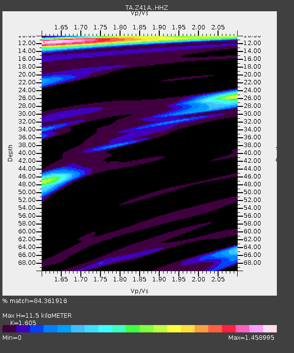
| Estimated Moho Depth: |
11.5 km |
| Estimated Crust Vp/Vs: |
1.61 |
| Assumed Crust Vp: |
6.245 km/s |
| Estimated Crust Vs: |
3.891 km/s |
| Estimated Crust Poisson's Ratio: |
0.18 |
|
| Radial Match: |
84.361916 % |
| Radial Bump: |
352 |
| Transverse Match: |
77.864655 % |
| Transverse Bump: |
344 |
| SOD ConfigId: |
7422571 |
| Insert Time: |
2019-04-21 06:33:13.438 +0000 |
| GWidth: |
2.5 |
| Max Bumps: |
400 |
| Tol: |
0.001 |
|
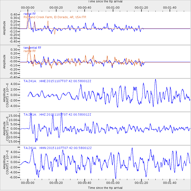
Signal To Noise
| Channel | StoN | STA | LTA |
| TA:Z41A: :HHZ:20151107T07:42:00.580012Z | 23.134682 | 6.8720287E-6 | 2.9704444E-7 |
| TA:Z41A: :HHN:20151107T07:42:00.580012Z | 5.038375 | 2.341839E-6 | 4.6480048E-7 |
| TA:Z41A: :HHE:20151107T07:42:00.580012Z | 1.4394222 | 9.891576E-7 | 6.871907E-7 |
| Arrivals |
| Ps | 1.2 SECOND |
| PpPs | 4.6 SECOND |
| PsPs/PpSs | 5.8 SECOND |


