You are here: Home > Network List > IC - New China Digital Seismograph Network Stations List
> Station BJT Baijiatuan, Beijing, China > Earthquake Result Viewer
BJT Baijiatuan, Beijing, China - Earthquake Result Viewer
| Earthquake location: |
Tonga Islands |
| Earthquake latitude/longitude: |
-20.2/-174.1 |
| Earthquake time(UTC): |
2006/05/03 (123) 15:26:40 GMT |
| Earthquake Depth: |
55 km |
| Earthquake Magnitude: |
7.2 MB, 7.8 MS, 7.9 MW, 7.9 MW |
| Earthquake Catalog/Contributor: |
WHDF/NEIC |
|
| Network: |
IC New China Digital Seismograph Network |
| Station: |
BJT Baijiatuan, Beijing, China |
| Lat/Lon: |
40.02 N/116.17 E |
| Elevation: |
197 m |
|
| Distance: |
88.3 deg |
| Az: |
313.893 deg |
| Baz: |
118.184 deg |
| Ray Param: |
0.042626172 |
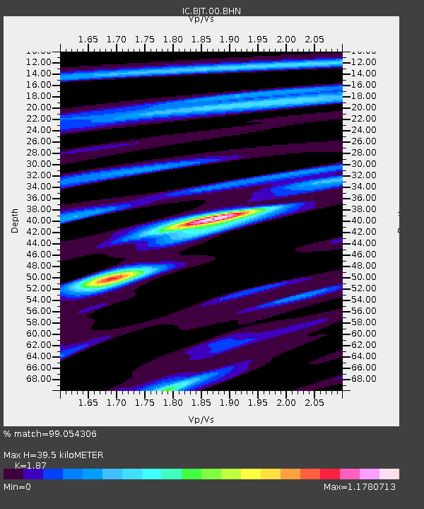
| Estimated Moho Depth: |
39.5 km |
| Estimated Crust Vp/Vs: |
1.87 |
| Assumed Crust Vp: |
6.464 km/s |
| Estimated Crust Vs: |
3.456 km/s |
| Estimated Crust Poisson's Ratio: |
0.30 |
|
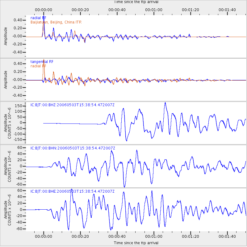
| Radial Match: |
99.054306 % |
| Radial Bump: |
328 |
| Transverse Match: |
96.69904 % |
| Transverse Bump: |
372 |
| SOD ConfigId: |
2669 |
| Insert Time: |
2010-03-04 21:36:54.461 +0000 |
| GWidth: |
2.5 |
| Max Bumps: |
400 |
| Tol: |
0.001 |
|
Signal To Noise
| Channel | StoN | STA | LTA |
| IC:BJT:00:BHN:20060503T15:38:54.472007Z | 3.7304132 | 1.3626254E-6 | 3.6527467E-7 |
| IC:BJT:00:BHE:20060503T15:38:54.472007Z | 5.2881556 | 3.3117647E-6 | 6.262608E-7 |
| IC:BJT:00:BHZ:20060503T15:38:54.472007Z | 7.106516 | 1.1458053E-5 | 1.6123306E-6 |
| Arrivals |
| Ps | 5.4 SECOND |
| PpPs | 17 SECOND |
| PsPs/PpSs | 23 SECOND |


