You are here: Home > Network List > WI - West Indies IPGP Network Stations List
> Station BIM Morne Bigot, Anses d'Arlets, Martinique > Earthquake Result Viewer
BIM Morne Bigot, Anses d'Arlets, Martinique - Earthquake Result Viewer
| Earthquake location: |
Near Coast Of Central Chile |
| Earthquake latitude/longitude: |
-30.9/-71.5 |
| Earthquake time(UTC): |
2015/11/07 (311) 07:31:42 GMT |
| Earthquake Depth: |
36 km |
| Earthquake Magnitude: |
6.8 MWP, 6.8 MI |
| Earthquake Catalog/Contributor: |
NEIC PDE/NEIC COMCAT |
|
| Network: |
WI West Indies IPGP Network |
| Station: |
BIM Morne Bigot, Anses d'Arlets, Martinique |
| Lat/Lon: |
14.52 N/61.07 W |
| Elevation: |
391 m |
|
| Distance: |
46.3 deg |
| Az: |
14.106 deg |
| Baz: |
192.492 deg |
| Ray Param: |
0.070672646 |
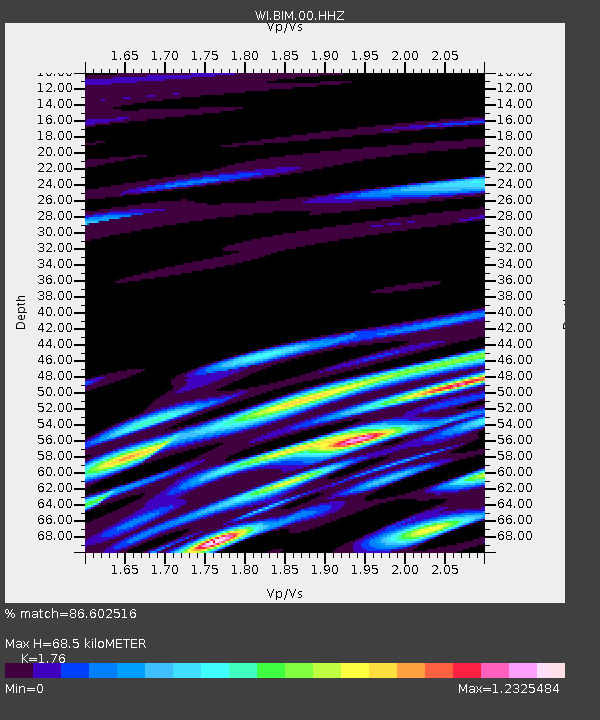
| Estimated Moho Depth: |
68.5 km |
| Estimated Crust Vp/Vs: |
1.76 |
| Assumed Crust Vp: |
5.88 km/s |
| Estimated Crust Vs: |
3.341 km/s |
| Estimated Crust Poisson's Ratio: |
0.26 |
|
| Radial Match: |
86.602516 % |
| Radial Bump: |
400 |
| Transverse Match: |
82.014175 % |
| Transverse Bump: |
400 |
| SOD ConfigId: |
7422571 |
| Insert Time: |
2019-04-21 06:34:35.985 +0000 |
| GWidth: |
2.5 |
| Max Bumps: |
400 |
| Tol: |
0.001 |
|

Signal To Noise
| Channel | StoN | STA | LTA |
| WI:BIM:00:HHZ:20151107T07:39:33.950007Z | 9.448569 | 1.0180936E-5 | 1.0775109E-6 |
| WI:BIM:00:HHN:20151107T07:39:33.950007Z | 4.637461 | 6.918036E-6 | 1.4917722E-6 |
| WI:BIM:00:HHE:20151107T07:39:33.950007Z | 3.6797423 | 4.9609116E-6 | 1.3481682E-6 |
| Arrivals |
| Ps | 9.3 SECOND |
| PpPs | 31 SECOND |
| PsPs/PpSs | 40 SECOND |


