You are here: Home > Network List > XD14 - Illuminating the architecture of the greater Mount St. Helens magmatic systems f Stations List
> Station MJ06 "Mount St Helens, WA" > Earthquake Result Viewer
MJ06 "Mount St Helens, WA" - Earthquake Result Viewer
| Earthquake location: |
Near Coast Of Central Chile |
| Earthquake latitude/longitude: |
-30.9/-71.5 |
| Earthquake time(UTC): |
2015/11/07 (311) 07:31:42 GMT |
| Earthquake Depth: |
36 km |
| Earthquake Magnitude: |
6.8 MWP, 6.8 MI |
| Earthquake Catalog/Contributor: |
NEIC PDE/NEIC COMCAT |
|
| Network: |
XD Illuminating the architecture of the greater Mount St. Helens magmatic systems f |
| Station: |
MJ06 "Mount St Helens, WA" |
| Lat/Lon: |
46.17 N/122.26 W |
| Elevation: |
976 m |
|
| Distance: |
89.4 deg |
| Az: |
327.455 deg |
| Baz: |
138.292 deg |
| Ray Param: |
0.041840382 |
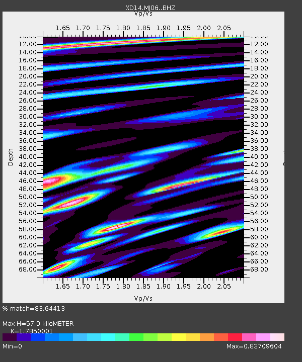
| Estimated Moho Depth: |
57.0 km |
| Estimated Crust Vp/Vs: |
1.79 |
| Assumed Crust Vp: |
6.566 km/s |
| Estimated Crust Vs: |
3.679 km/s |
| Estimated Crust Poisson's Ratio: |
0.27 |
|
| Radial Match: |
83.64413 % |
| Radial Bump: |
400 |
| Transverse Match: |
86.11992 % |
| Transverse Bump: |
400 |
| SOD ConfigId: |
7422571 |
| Insert Time: |
2019-04-21 06:35:19.053 +0000 |
| GWidth: |
2.5 |
| Max Bumps: |
400 |
| Tol: |
0.001 |
|

Signal To Noise
| Channel | StoN | STA | LTA |
| XD:MJ06: :BHZ:20151107T07:44:04.470027Z | 11.121398 | 2.4814099E-6 | 2.2312034E-7 |
| XD:MJ06: :BHN:20151107T07:44:04.470027Z | 3.2457259 | 8.3946185E-7 | 2.586361E-7 |
| XD:MJ06: :BHE:20151107T07:44:04.470027Z | 2.1532705 | 7.2172475E-7 | 3.3517605E-7 |
| Arrivals |
| Ps | 7.0 SECOND |
| PpPs | 24 SECOND |
| PsPs/PpSs | 31 SECOND |


