You are here: Home > Network List > CI - Caltech Regional Seismic Network Stations List
> Station PAS Pasadena, Pasadena, CA, USA > Earthquake Result Viewer
PAS Pasadena, Pasadena, CA, USA - Earthquake Result Viewer
| Earthquake location: |
Near Coast Of Chiapas, Mexico |
| Earthquake latitude/longitude: |
15.0/-92.4 |
| Earthquake time(UTC): |
2000/03/12 (072) 22:21:30 GMT |
| Earthquake Depth: |
62 km |
| Earthquake Magnitude: |
5.5 MB, 5.8 MS, 6.3 MW, 5.4 MD |
| Earthquake Catalog/Contributor: |
WHDF/NEIC |
|
| Network: |
CI Caltech Regional Seismic Network |
| Station: |
PAS Pasadena, Pasadena, CA, USA |
| Lat/Lon: |
34.15 N/118.17 W |
| Elevation: |
314 m |
|
| Distance: |
30.1 deg |
| Az: |
314.043 deg |
| Baz: |
123.104 deg |
| Ray Param: |
0.07934495 |
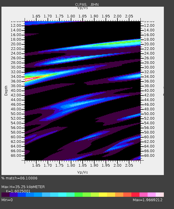
| Estimated Moho Depth: |
35.25 km |
| Estimated Crust Vp/Vs: |
1.60 |
| Assumed Crust Vp: |
6.1 km/s |
| Estimated Crust Vs: |
3.807 km/s |
| Estimated Crust Poisson's Ratio: |
0.18 |
|
| Radial Match: |
86.10886 % |
| Radial Bump: |
293 |
| Transverse Match: |
73.498825 % |
| Transverse Bump: |
400 |
| SOD ConfigId: |
3744 |
| Insert Time: |
2010-02-25 23:54:02.618 +0000 |
| GWidth: |
2.5 |
| Max Bumps: |
400 |
| Tol: |
0.001 |
|

Signal To Noise
| Channel | StoN | STA | LTA |
| CI:PAS: :BHN:20000312T22:27:03.57199Z | 0.6145833 | 3.3396776E-7 | 5.4340524E-7 |
| CI:PAS: :BHE:20000312T22:27:03.57199Z | 2.0150652 | 4.4187223E-7 | 2.1928432E-7 |
| CI:PAS: :BHZ:20000312T22:27:03.57199Z | 4.0909724 | 8.097116E-7 | 1.9792644E-7 |
| Arrivals |
| Ps | 3.8 SECOND |
| PpPs | 14 SECOND |
| PsPs/PpSs | 18 SECOND |


